place

Pilton West

Civil parishes in DevonDevon geography stubsNorth Devon
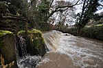
A weir and sluice gate on Bradiford Water in Tutshill Wood geograph.org.uk 2223583

Pilton West is a rural civil parish of North Devon, Devon, England, immediately north-west of the suburb of Pilton in the town of Barnstaple. The parish was created as "West Pilton" in 1894 from the parts of the ancient parish of Pilton which lay outside the borough boundaries of Barnstaple. The parish was renamed Pilton West in 1999. In 2019, the population of Pilton West was 253, and its area was around 1.6 square miles (4.16 square kilometres). The parish is older than the national average — 28% of the local residents are over 65, compared to 18% of the British population — and it is overwhelmingly white, with the 2011 census finding that all but one of the parish's residents identified themselves as white. It elects a parish council, the clerk of which is Geoff Dwyer.The parish spans a wide tract of land to the north-west of Barnstaple, from the River Yeo and Smoky House Lane in the east to the banks of the River Taw's estuary and a short section of the A361 road in the south-west. The A39 road — named here as Shirwell Road — and Upcott Hill run north–south through the parish, connecting it with Pilton proper. There is also a north–south right of way that follows the path of a rivulet called the Colm Stream or Bradiford Water, and next to the right of way, a copse called Tutshill Woods. One traveller reports that Tutshill Woods is a popular dog-walking spot.

Excerpt from the Wikipedia article Pilton West (License: CC BY-SA 3.0, Authors, Images).

Pilton West
Upcott Hill, North Devon Pilton West

Geographical coordinates (GPS) Address Nearby Places
placeShow on map

Wikipedia: Pilton WestContinue reading on Wikipedia

Geographical coordinates (GPS)

Latitude Longitude
N 51.0956 ° E -4.0734 °
placeShow on map

Address

Upcott Hill

Upcott Hill
EX31 4AP North Devon, Pilton West
England, United Kingdom
mapOpen on Google Maps

A weir and sluice gate on Bradiford Water in Tutshill Wood geograph.org.uk 2223583
Share experience

Nearby Places

Pilton, Devon
Pilton, Devon

Pilton is a suburb of the town of Barnstaple, it is located about quarter of a mile north of the town centre, in the civil parish of Barnstaple, in the North Devon district, in the county of Devon, England. It was formerly a separate village. The civil parish of Pilton West covers the more rural parts of the ancient parish of Pilton that have not been incorporated into the town of Barnstaple. In 2009, the Pilton (Barnstaple) ward had a population of 4,239 living in some 1,959 dwellings. It has its own infants and junior school, houses one of Barnstaple's larger secondary schools, and one of Barnstaple's SEN specialist schools. North Devon Hospital is also within West Pilton parish. It has a Church Hall, two public houses, two hotels, and residential homes. It has residential estates of both private and public housing including flats. It also has a historic Church that dates back to at least the 11th Century. It was once separated from the adjacent town of Barnstaple by the River Yeo. Sir John Stowford (born c.1290 died c.1372) of Stowford, West Down. Chief Baron of the Exchequer built Pilton Causeway which links the town of Barnstaple and village of Pilton, which were then separated by the treacherous marshy ground in which flowed the tidal meanders of the small River Yeo. It is recounted by John Prince (1643–1723), that Stowford decided on building the causeway when on his way from his home at Stowford, north of Pilton, to Barnstaple, he met whilst fording the Yeo the drowned bodies of a woman with her child. He is also believed to have contributed to the financing of the long-bridge in Barnstaple.

Pilton railway station

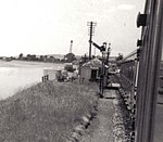
Pilton Yard, in Barnstaple was, between 1898 and 1935, the main depot and operating centre of the Lynton and Barnstaple Railway ('L&B'), a narrow gauge line that ran through Exmoor from Barnstaple to Lynton and Lynmouth in north Devon, England. Pilton station was served by regular passenger services advertised between 1898 and 1904 after which only goods facilities were provided. Passengers were catered for at the nearby LSWR station, Barnstaple Town, which provided connections with trains on the standard gauge branch line to Ilfracombe. The L&B's main offices were also based at Pilton, in a building formerly belonging to the Tannery which had earlier occupied the site, and which took over the site after the railway closed. Pilton was the site of the L&B's only turntable. Locomotives always travelled with their boilers facing "down" the line, i.e. towards Lynton (down as it was away from London by rail, although geologically, Lynton was higher, and geographically nearer to London). The turntable was used to turn rolling stock periodically to even-out bearing wear. After closure, the turntable was installed at the Romney, Hythe & Dymchurch Railway in Kent, but is now owned by the Lynton and Barnstaple Railway Trust and in storage for eventual restoration and reuse on the new L&B. The carriage sheds, locomotive shed and other remnants of the railway were destroyed in a fire in 1992. Much of the site is now a car park, although there are still signs of its former railway use.