place

Normalnull

Cartography stubsGeography of GermanyVertical datumsZero-level elevation points
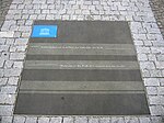
Borne de nivellement Kriegstor

Normalnull ("standard zero") or Normal-Null (short N. N. or NN ) is an outdated official vertical datum used in Germany. Elevations using this reference system were to be marked Meter über Normal-Null (“meters above standard zero”). Normalnull has been replaced by Normalhöhennull (short NHN).

Excerpt from the Wikipedia article Normalnull (License: CC BY-SA 3.0, Authors, Images).

Normalnull
Friedrichstraße, Berlin Kreuzberg

Geographical coordinates (GPS) Address Nearby Places
placeShow on map

Wikipedia: NormalnullContinue reading on Wikipedia

Geographical coordinates (GPS)

Latitude Longitude
N 52.5034 ° E 13.393 °
placeShow on map

Address

Miniloft

Friedrichstraße 23
10969 Berlin, Kreuzberg
Germany
mapOpen on Google Maps

Borne de nivellement Kriegstor
Share experience

Nearby Places

Berlin Observatory
Berlin Observatory

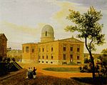
The Berlin Observatory (Berliner Sternwarte) is a German astronomical institution with a series of observatories and related organizations in and around the city of Berlin in Germany, starting from the 18th century. It has its origins in 1700 when Gottfried Leibniz initiated the "Brandenburg Society of Science″ (Sozietät der Wissenschaften) which would later (1744) become the Prussian Academy of Sciences (Preußische Akademie der Wissenschaften). The Society had no observatory but nevertheless an astronomer, Gottfried Kirch, who observed from a private observatory in Berlin. A first small observatory was furnished in 1711, financing itself by calendrical computations. In 1825 Johann Franz Encke was appointed director by King Frederick William III of Prussia. With the support of Alexander von Humboldt, Encke got the King to agree to the financing of a true observatory, but one condition was that the observatory be made accessible to the public two nights per week. The building was designed by the well-known architect Karl Friedrich Schinkel, and began operating in 1835. It now bears the IAU observatory code 548. Although the original observatory was built in the outskirts of the city, over the course of time the city expanded such that after two centuries the observatory was in the middle of other settlements which made making observations very difficult and a proposal to move the observatory was made. The observatory was moved to Potsdam-Babelsberg in 1913 (IAU observatory code 536). Since 1992 it is managed by the Leibniz Institute for Astrophysics Potsdam (AIP), although it has not been used for German astronomical observations since the 20th century. In Berlin remain the Wilhelm Foerster Observatory (IAU code 544), the Archenhold Sternwarte, Berlin-Treptow (Archenhold Observatory; IAU code 604), the Urania Sternwarte (Urania Observatory, IAU code 537), and the Bruno H. Bürgel Observatory.

Mehringplatz
Mehringplatz

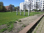
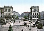
Mehringplatz is a round plaza (or circus) at the southern tip of the Friedrichstadt neighborhood of Kreuzberg district, Berlin. It marks the southern end of Friedrichstraße. Until 1970 both Lindenstraße and Wilhelmstrasse led into it. In 1947 it was renamed after the publicist Franz Mehring (1846–1919). Mehringplatz is one of three prominent squares laid out about 1730 in the course of the city's Baroque extension under King Frederick William I of Prussia, along with Pariser Platz (former Karree) and Leipziger Platz (Octagon). Due to its circular shape, Mehringplatz was initially named Rondell; but on 22 October 1815, it was renamed Belle-Alliance-Platz after the Battle of La Belle Alliance, an alternative name for the Battle of Waterloo that was then popular in Prussia. Rondell was the southern entrance to Berlin via Hallesches Tor, a gate on the newer city wall on the outbound road to Halle. The circus was refurbished during the 1830s, including the erection of the Friedenssäule ("Peace Column") with a statue of Victoria by Christian Daniel Rauch in 1843. The area was completely devastated in World War Two, particularly in an air raid on 3 February 1945 and the Battle of Berlin which followed. In the 1960s, Mehringplatz was redeveloped as a pedestrian zone that would anchor a large social housing area according to the realization of a plan conceived by Hans Scharoun, which was ultimately executed by the Berlin architect Werner Düttmann. During the 1990s, the installation of striking murals was used to decorate the lower walls of the courtyard areas of the housing blocks.