place

Betty Mundy's Bottom

Geography of HampshireHampshire geography stubsUse British English from April 2021Valleys of England
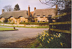
Betty Mundy's Bottom geograph.org.uk 96569

Betty Mundy's Bottom is a wooded valley in the South Downs of Hampshire. There are a variety of folk tales about the name, which goes back centuries. One theory is that it is from the Latin beati mundae, meaning the most beautiful place in the world. Another has it that Betty Mundy lived in a cottage there and that she would waylay discharged sailors walking along the Sailor's Lane, murdering them for their wages or leading them to a press gang. Other stories are that she was a witch or fairy that would curse or trick people.In 1941, there was building work to renovate two cottages owned by Major Pelly. In 2012, a substantial country house known as Mundy's House was rebuilt there.

Excerpt from the Wikipedia article Betty Mundy's Bottom (License: CC BY-SA 3.0, Authors, Images).

Betty Mundy's Bottom
Mundy’s Walk, Winchester Exton

Geographical coordinates (GPS) Address Nearby Places
placeShow on map

Wikipedia: Betty Mundy's BottomContinue reading on Wikipedia

Geographical coordinates (GPS)

Latitude Longitude
N 50.99679947 ° E -1.17394469 °
placeShow on map

Address

Mundy’s Walk
SO32 3LP Winchester, Exton
England, United Kingdom
mapOpen on Google Maps

Betty Mundy's Bottom geograph.org.uk 96569
Share experience

Nearby Places

Preshaw

Preshaw (variously named Presshawe, Presthawe, and Preishawe in old documents) is a manor to the north of Corhampton in the United Kingdom. In the 19th century the mansion house Preshaw House was the seat of William Jarvis Long, who also owned three farmlands on the estate, Little Preshaw, Middle Preshaw, and Lower Preshaw, to a total of 3,225 acres (1,305 ha) in Hampshire. The estate was at the time split across two parishes, Little and Middle Preshaw being in Exton parish and Lower Preshaw in Upham parish.It was probably under the manor of Lormer (in Cleverly) in the Domesday Book, it having been granted along with that manor in 1542 to William Paulet, whose descendants sold in 1707 to Robert Kirby, who in turn bequeathed it on his death in 1721 to his cousins in order to pay off debts to his relatives, who in their turn sold it in 1727 to John Long for £7,600. Long left the manor to Walter, his brother, it eventually ending up in the possession of William Jarvis Long. William Jarvis Long was the last of the Longs to inhabit the manor, as he sold it in 1898 to [ William Baron de Bush ], who then sold it in 1901 to Reginald Harry Cholmondeley.The manor house itself is a two story house built of flint with brick dressing that sits on the slope of Millbarrow Down. Its architecture dates it to the 1630s, although it has undergone two significant renovations and additions; including the addition of two gables (to the then existing three) on the front of the house as well as an additional block on the east end in the 18th century, and a further set of rooms on the south of the building in the 19th century. The 18th century additions are close enough to the original to be only noticeable upon close inspection, neither quite matching the older building, the former being entirely faced with brick and having no flint, and the latter using cement. The windows are not the original wooden frames, and the porch on the west side of the house with its modern door was probably not a porch originally.

Exton, Hampshire
Exton, Hampshire

Exton is a small village and civil parish in the City of Winchester district of Hampshire, England. The village lies in the South Downs National Park, on the west bank of the River Meon, immediately to the north of Corhampton. It is located two miles north of Droxford and five miles north-east of Bishop's Waltham. Its name first appears in 940 as East Seaxnatune, meaning "farmstead of the East Saxons".The parish straddles the Meon Valley, including higher ground of the South Downs to either side, with Old Winchester Hill to the east and the southern part of Beacon Hill (shared with Warnford parish) to the west. It is crossed from east to west by the South Downs Way long-distance footpath. The A32 and the Meon Valley Railway footpath cross from north to south. The parish contains numerous archaeological sites including a Mesolithic flint working site, Bronze Age bowl barrows and the Iron Age fort at Old Winchester Hill. There are also Roman and Dark Age sites and the site of the mediaeval village of Lomer. The 13th-century church of St Peter and St Paul was heavily restored in the 19th century. The 1892 restoration (the second of the 19th century) added stained glass windows by Charles Spooner in the style of the Arts and Crafts movement.Exton has remained a small community for more than two centuries. In 1801 Exton's total population was 224, by 1901 it had grown slightly to 299 yet by 2001 the population had shrunk to 230 and again to 203 at the 2011 Census. Photographs from the 1950s show a village shop and post office in Exton but this closed in the 1960s. The only community buildings in the village are the church and the Shoe Inn public house. In 1870–72, John Goring's Imperial Gazetteer of England and Wales described Exton like this: "EXTON, a village and a parish in Droxford district, Hants. The village stands 2 miles N by E of Droxford, and 5 NE of Bishops-Waltham r. station; and has a post office under Southampton. The parish comprises 2,464 acres (10 km²). Real property, £2,640. Pop., 257. Houses, 41. Exton Lodge is a principal residence. The living is a rectory in the diocese of Winchester. Value, 331.* Patron, the Bishop of Winchester. The church was rebuilt in 1847, and is in the early English style. "