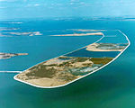
Sturgeon Bar
Islands of Wayne County, MichiganIslands of the Detroit RiverRiver islands of MichiganSoutheast Michigan geography stubs

Sturgeon Bar (or Sturgeon's Bar) is a small island in the Detroit River. It is in Wayne County, in southeast Michigan. Its coordinates are 42°04′07″N 83°11′17″W, and the United States Geological Survey gave its elevation as 571 ft (174 m) in 1980. Numerous types of fish spawn at the island; a 1982 report by the U.S. Fish and Wildlife Service listed lake sturgeon,: 4 gizzard shad,: 6 goldfish,: 11 carp,: 14 emerald shiner,: 15 channel catfish,: 19 bullhead catfish,: 19 bluegill,: 23 smallmouth bass,: 25 and crappie.: 26
Excerpt from the Wikipedia article Sturgeon Bar (License: CC BY-SA 3.0, Authors, Images).Sturgeon Bar
Cherry Island Trail,
Geographical coordinates (GPS) Address Nearby Places Show on map
Geographical coordinates (GPS)
| Latitude | Longitude |
|---|---|
| N 42.068611111111 ° | E -83.188055555556 ° |
Address
Sturgeon Bar
Cherry Island Trail
48173
Michigan, United States
Open on Google Maps


