Rogue Valley AVA

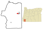
The Rogue Valley AVA is an American Viticultural Area located in southern Oregon. The federal government approved this appellation in 1991. It is entirely contained within the larger Southern Oregon AVA and includes the drainage basin of the Rogue River and several tributaries, including the Illinois River, the Applegate River, and Bear Creek. Most wineries in the region are found in the valleys formed by one of these three tributaries, rather than along the Rogue River itself. The region is 70 miles (113 km) wide by 60 miles (97 km) long (most of the land within the AVA capable of producing high quality wine is not currently used for grape cultivation); there are fewer than 20 wineries with only 1,100 acres (450 ha) planted. Each river valley has a unique terroir, and grows different varieties of grapes. Overall, however, this region is the warmest and driest of Oregon's wine-growing regions.
Excerpt from the Wikipedia article Rogue Valley AVA (License: CC BY-SA 3.0, Authors, Images).Rogue Valley AVA
Redwood Avenue,
Geographical coordinates (GPS) Address Nearby Places Show on map
 Continue reading on Wikipedia
 Geographical coordinates (GPS)
| Latitude | Longitude |
|---|---|
| N 42.416666666667 ° | E -123.41666666667 ° |
Address
Redwood Avenue
Redwood Avenue
97527
Oregon, United States
Open on Google Maps