place

Ashepoo River

Rivers of Colleton County, South CarolinaRivers of South CarolinaSouth Carolina geography stubsSouthern United States river stubs

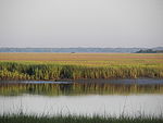
Ashepoo River is a short blackwater river in South Carolina, United States. It rises in a confluence of swamps south of Walterboro, flows in a southeast direction and empties into Saint Helena Sound at 32.49°N 80.42389°W / 32.49; -80.42389. The entire course of the river lies within the boundaries of Colleton County.The Ashepoo basin forms part of the ACE Basin, a coastal conservation area that encompasses its bottomlands confluence with the Combahee and Edisto river basins. (The refuge's name is formed from the first letters of the names of the three rivers: A-C-E). The name comes from the Ashepoo subtribe of the Cusabo Indians. Caeser P. Chisolm received a charter to operate ferry service across the Ashepoo River.During the American Civil War the river was the site of an incursion between Union, and Confederate troops. The 34th Infantry Regiment was ordered to burn a railroad trestle near the river, they boarded the troop steamer Boston but became stranded on an oyster bed. The stranded boat was shelled by nearby Confederate batteries. The men on board were ferried off under fire by Union troops led by George W. Brush.

Excerpt from the Wikipedia article Ashepoo River (License: CC BY-SA 3.0, Authors).

Geographical coordinates (GPS)

Latitude Longitude
N 32.490277777778 ° E -80.423611111111 °
placeShow on map

Address

Colleton County


South Carolina, United States
mapOpen on Google Maps

Share experience

Nearby Places

Ashepoo Combahee Edisto Basin National Estuarine Research Reserve

The Ashepoo Combahee Edisto Basin National Estuarine Research Reserve (often shortened to ACE Basin NERR) is a 140,000-acre (570 km2) reserve area located in the ACE Basin, one of the largest undeveloped estuaries on the Atlantic coast of the United States. It is named for the Ashepoo, Combahee and Edisto Rivers, which flow past cypress swamps, historic plantation houses, old rice fields and tidal marshes to meet at South Carolina's biologically rich St. Helena Sound. The ACE Basin NERR is intended to protect the natural environment, wildlife and cultural heritage of the area. The reserve also preserves the habitat of a number of endangered or threatened species, such as shortnose sturgeon, wood storks, loggerhead sea turtles and bald eagles. Commercial fisherman harvest supplies of shrimp, crab, oyster, clam and finfish each year in the ACE Basin. Recreational fishermen ply the mudflats for spottail bass, flounder and shrimp, while paddlers visit the salt marsh creeks and the black waters of the rivers.Research conducted at the ACE Basin NERR enhance the protection of these commercial and recreational uses by monitoring water quality, providing information on the number and types of plant and animal species, and evaluating the overall health of the ACE Basin ecosystem.Through a number of educational programs, the reserve provides information to coastal decision makers, lawmakers, teachers, students and the general public. The reserve sponsors a summer lecture series, develops curriculum materials for teachers, offers a touch tank program for children and conducts educational cruises where students and teachers learn about estuaries and their values to marine, avian and human life.