Rampart Ridge (Washington)

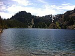
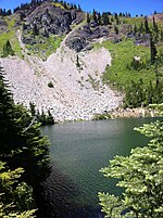
Rampart Ridge is a 5,870 ft (1,790 m) elevation mountain ridge located in the Cascade Range, in Kittitas County of Washington state. It is situated northeast of Hyak, Washington, and the north end of Keechelus Lake, within the Alpine Lakes Wilderness, on land managed by Wenatchee National Forest. Its nearest higher peak is Alta Mountain, 1.74 mi (2.80 km) to the north-northeast, and Dungeon Peak rises 0.77 mi (1.24 km) to the south-southwest. The north-south trending ridge is characterized by vertical cliffs on its west-facing side above the Gold Creek valley, and gentle meadows with lakes on the eastern side, such as Rachel Lake, Lake Lillian, and the Rampart Lakes. The descriptive name of rampart was officially adopted 1918 by the United States Board on Geographic Names based on a suggestion by The Mountaineers. Precipitation runoff from the ridge drains into tributaries of the Yakima River.
Excerpt from the Wikipedia article Rampart Ridge (Washington) (License: CC BY-SA 3.0, Authors, Images).Rampart Ridge (Washington)
Rampart Lakes Backdoor Trail,
Geographical coordinates (GPS) Address Nearby Places Show on map
Geographical coordinates (GPS)
| Latitude | Longitude |
|---|---|
| N 47.411398 ° | E -121.344768 ° |
Address
Rampart Lakes Backdoor Trail
Rampart Lakes Backdoor Trail
Washington, United States
Open on Google Maps


