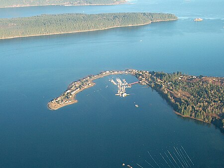
Deep Bay, British Columbia
Bays of British ColumbiaBritish Columbia Coast geography stubsPopulated places in the Regional District of NanaimoPorts and harbours of British ColumbiaUnincorporated settlements in British Columbia ... and 2 more
Use Canadian English from January 2023Use mdy dates from September 2023

Deep Bay is an unincorporated area on the east coast of Vancouver Island, in British Columbia, Canada across Baynes Sound from Denman Island which has a government marina in a naturally protected harbour. It is situated on Highway 19A north of Qualicum Beach between Fanny Bay and Bowser. The June 23, 1946 Vancouver Island earthquake shocked the Strait of Georgia region, causing the bottom of Deep Bay to sink between 2.7 m (9 ft) and 25.6 m (84 ft). Deep Bay is the home of the Deep Bay Marine Field Station. The Island Rail Corridor passes through the area, although there is no longer a train service in operation.
Excerpt from the Wikipedia article Deep Bay, British Columbia (License: CC BY-SA 3.0, Authors, Images).Deep Bay, British Columbia
Crome Point Road, Area H (Lighthouse Country)
Geographical coordinates (GPS) Address Nearby Places Show on map
Geographical coordinates (GPS)
| Latitude | Longitude |
|---|---|
| N 49.465277777778 ° | E -124.72666666667 ° |
Address
Crome Point Road
V0R 1G0 Area H (Lighthouse Country)
British Columbia, Canada
Open on Google Maps


