place

Necropolis of Carenque

AC with 0 elementsNational monuments in Lisbon DistrictPrehistoric sites in Portugal
NecropolisCarenque1
NecropolisCarenque1

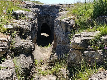
The Necropolis of Carenque (Portuguese: Necrópole de Carenque) is an archaeological site consisting of three well-preserved late Neolithic collective sepulchres or tombs, dating back to about 3000 BCE, which are dug into smooth limestone outcrops. It is situated in the municipality of Amadora in the Lisbon District of Portugal.

Excerpt from the Wikipedia article Necropolis of Carenque (License: CC BY-SA 3.0, Authors, Images).

Necropolis of Carenque
Trilho da Necrópole de Carenque, Mina de Água Casal de São Brás

Geographical coordinates (GPS) Address External links Nearby Places
placeShow on map

Wikipedia: Necropolis of CarenqueContinue reading on Wikipedia

Geographical coordinates (GPS)

Latitude Longitude
N 38.773333333333 ° E -9.2438888888889 °
placeShow on map

Address

Necrópole de Carenque (Grutas artificiais do Tojal de Vila Chã ou Carenque;Grutas artificiais de Carenque;Grutas Artificiais do Tojal de Vila Chã)

Trilho da Necrópole de Carenque
2700-621 Mina de Água, Casal de São Brás
Portugal
mapOpen on Google Maps

linkWikiData (Q10335950)
linkOpenStreetMap (306992977)

NecropolisCarenque1
NecropolisCarenque1
Share experience

Nearby Places

Monumento ao Bombeiro

The Monumento ao Bombeiro or Monument to the Firefighter is a monument/memorial located in the civil parish of Belas, in the municipality of Sintra, in the central region of Portugal. The Monumento was designed to honour the service and sacrifice of several firemen, who lost their lives in 1967, during their efforts to rescue people during the torrential downpours that breached the banks of the Jamor River, causing heavy flooding. In addition to the firemen, many people lost their lives and extensive property damage.Dedicated to Belas' Volunteer Firefighters, the monument was officially dedicated on 24 November 2002, with the presence of the Secretário de Estado adjunto do Ministério da Administração Interna (Adjunct-Secretary of State for the Ministry of Internal Administration), Luís Pais de Sousa and president of the municipality, Fernando Seara, along with other politicians, dignitaries and officials, marking the 35th anniversary of the tragedy. In a speech addressing the crowd, the president of the parish council, Guilherme Dias, reminded the crowd that the statute "served to demonstrate to the people, the respect [we] have for the firefighters. At the bottom we transform in bronze our collective sentiment". In addition to the inauguration, the event served to inaugurate the new vehicles and forest-fighting equipment, ambulances and generators that were acquired for the institution.A medal was impressed officially to honour the firefighters and pay homage to the people who died in the tragedy.The monument was designed and created by the artist Bottelho.

Anta do Monte Abraão

The Anta do Monte Abraão was a megalithic dolmen located in the parish of Monte Abraão, in Queluz, Sintra Municipality, Lisbon District, Portugal. The dolmen was first identified in 1876, by Carlos Ribeiro, who carried out excavations until 1878 and published his results in 1880. Excavations suggest that it served as a tomb for about 80 individuals and that it dates back to the middle to end of the Neolithic period (4000-2500 BC). The Anta do Monte Abraão and the nearby Anta da Pedra dos Mouros (also known as the Anta do Senhor da Serra) and Anta da Estria are collectively known as the Antas de Belas.The burial chamber of the Anta do Monte Abraão had an east-west orientation. It had at least six upright limestone supporting stones or orthostats and three of these were found in situ by Ribeiro. The polygonal chamber had a diameter of 3.6 metres, approached by an 8 metre corridor that was 2 metres wide. Subsequent work by Vergílio Correia Pinto da Fonseca identified limited drawings on some stones. Despite the destruction of the tomb, excavations have yielded numerous finds, including stone axes, flint tools and blades, flint arrowheads, club heads, pottery ceramics, clay vessels and objects of adornment. These are exhibited at the Portuguese Geological Museum in Lisbon. Apart from the visit by Da Fonseca, Ribeiro’s findings attracted little interest in the dolmen until the 1960s, when archaeologists became concerned about the possible destruction of the Antas de Belas as a result of urban expansion and highway construction. In addition, the Anta do Monte Abrãao was threatened by the activity of a quarry located in its vicinity. The present condition of the stones is poor and extensive graffiti is visible.

Anta da Pedra dos Mouros

The Anta da Pedra dos Mouros (Stone of the Moors), also known as the Anta do Senhor da Serra (Lord of the Mountains), is a megalithic dolmen situated near Belas and Queluz in the Lisbon District of Portugal. It is believed to date back to the late-Neolithic and early-Chalcolithic eras (4000-2500 BC). The Anta da Pedra dos Mouros, the Anta da Estria, and the Anta do Monte Abraão are a short distance from each other and are collectively known as the Antas de Belas. The Anta da Pedra dos Mouros was first identified in the 1850s by Carlos Ribeiro. Despite being registered and protected as a national monument in 1910, the dolmen has recently suffered significant damage.The Anta da Pedra dos Mouros was reportedly first identified in 1856 by Carlos Ribeiro (1813-1882) but he did not have a chance to carry out excavations until 1876 after receiving approval from the landowner, the Marquis of Belas. The burial chamber was at that time already in bad condition, having only three upright support stones, with one apparently having two anthropomorphic figures engraved on it. Ribeiro found three remaining orthostats in situ. The largest one was sloping to the north, 5 meters long, 3.7 m wide and 0.27 m thick. This was partially supported by a second piece, 4.5 m long, 2 m wide and 0.25 m thick, which was in contact with the third stone, which was about 4 meters wide, but rose only one meter above the ground, since it was broken. There were no visible fragments around. During the excavation, Ribeiro also found four smaller slabs. Ribeiro and subsequent studies (by Ferreira, G. and V. Leisner and Boaventura) have produced differing interpretations of both the exact structure of the sepulchre and its orientation. Items found by Ribeiro during his excavations are kept in the Geological Museum in Lisbon. They include a stone axe, flint tools, utensils for domestic use, vases, and human and animal bones. Ribeiro noted that the contents of the tomb had already been disturbed, and that his findings were "not very fruitful". This impression was confirmed by the presence in the spoils of a Portuguese coin dated 1741 and by information from local inhabitants who advised Ribeiro that the tomb had been raided a decade before his excavations. However, contrary to the opinion of Ribeiro (1880) and later authors, the items collected, although scarce, do allow for an overall understanding of the tomb.The site had for a long time been one of pilgrimage for the local population, it being believed that newly married women who slid down the side of the dominant stone would then be able to conceive. These pilgrimages came to an end in 1942 when the landowner forbade access. The dominant stone was found shattered into numerous pieces in June 2010: it remains unclear whether this was caused by vandalism or was the result of detonations during construction of the new A9 Motorway, which passes close to the dolmen.
Anta da Estria
Anta da Estria

The Anta da Estria is a megalithic dolmen situated between Belas and Queluz in the Lisbon District of Portugal. Based on datings of human remains, it is believed to date back to the late-Neolithic and early-Chalcolithic eras (4000-2500 BC). The Anta da Estria, the Anta do Monte Abraão and the Anta da Pedra dos Mouros (also known as the Anta do Senhor da Serra) are collectively known as the Antas de Belas, and were first identified in the 1870s by Carlos Ribeiro (1813-1882), who is regarded as the "father" of Portuguese prehistoric archaeology.The dolmen is presently in a much-degraded condition and difficult to access. It was almost destroyed by construction in the 1990s of Portugal’s A9 motorway but was eventually incorporated into the landscaped area of a service station for that highway, facilitating easy access. However, the service area has since been closed and access by cars has been blocked. Pedestrian access remains possible, using a footbridge over a motorway slip road. Carlos Ribeiro, who carried out research in early 1875 and published his results in 1880, described the tomb as having a polygonal chamber, 2-5 metres wide and 2.75 metres high, approached by a corridor bordered by small slabs of limestone. Later excavations carried out by what is now the Portuguese Institute of Architectural and Archaeological Heritage (IPPAR), of the Direção-Geral do Património Cultural (Directorate-General for Cultural Heritage), under the direction of Ana Carvalho Dias have shown the corridor to make use of a pre-existing inclined depression in the rock. This dictated the orientation of the tomb, which points to 212-13 degrees west. Ribeiro identified nine raised slabs but did not identify any stones that could have formed a roof. He considered all of the slabs to have been locally sourced, and this has been confirmed by subsequent research. The hard limestone is similar to that used for the other Antas de Belas. Limited artifacts have been discovered at the site but many are thought to have been removed prior to the discovery by Ribeiro. Twelve arrowheads were identified, together with two bone artifacts and three small, almost-complete pots. While human remains were found, Ribeiro did not feel confident to identify the number of burials that had taken place at the tomb, which he had done for the Anta do Monte Abraão.