Mettingham

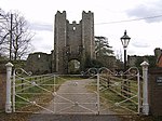
Mettingham is a village and civil parish in the north of the English county of Suffolk. It is 2 miles (3.2 km) east of the market town of Bungay in the East Suffolk district. It had a population of 211 at the 2011 United Kingdom census.The northern boundary of the parish is formed by the River Waveney which marks the county boundary with Norfolk. The northern section of the parish is within the area of The Broads National Park. The parish borders the parishes of Bungay, Shipmeadow, Ilketshall St John and the Norfolk parishes of Broome and Ellingham. The B1062 Bungay to Beccles road runs through the centre of the parish.In the 1870s, Mettingham was described as: "a village and a parish in Wangford district, Suffolk. The village stands near the river Waveney, at the boundary with Norfolk, 2 miles E of Bungay r. station; is a scattered place; and has a postoffice under Bungay."Its church, All Saints, is a round-tower church and about a mile to the south, Mettingham Castle comprises the ruins of a moated medieval fortified manor house, with a medieval monastic college, Mettingham College, in its grounds. The college was relocated to the site in 1394 and was dissolved in 1542 during the Dissolution of the Monasteries.
Excerpt from the Wikipedia article Mettingham (License: CC BY-SA 3.0, Authors, Images).Mettingham
B1062, East Suffolk
Geographical coordinates (GPS) Address Nearby Places Show on map
Geographical coordinates (GPS)
| Latitude | Longitude |
|---|---|
| N 52.457 ° | E 1.474 ° |
Address
B1062
NR35 1TL East Suffolk
England, United Kingdom
Open on Google Maps


