place

French Flat

Former populated places in California by countyFormer settlements in Tuolumne County, CaliforniaHistory of Tuolumne County, CaliforniaSierra Nevada geography stubs

French Flat or French Camp now a ghost town was in Tuolumne County, California. It was located near French Flat from which it took its name, one and a half miles south southwest of Tuttletown. Its location was near the flat, northwest of an 1,894-foot (577 m) mountain.

Excerpt from the Wikipedia article French Flat (License: CC BY-SA 3.0, Authors).

French Flat
French Flat Road,

Geographical coordinates (GPS) Address Nearby Places
placeShow on map

Wikipedia: French FlatContinue reading on Wikipedia

Geographical coordinates (GPS)

Latitude Longitude
N 37.972222222222 ° E -120.47138888889 °
placeShow on map

Address

French Flat Road 8001
95327
California, United States
mapOpen on Google Maps

Share experience

Nearby Places

New Melones Dam
New Melones Dam

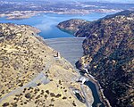
New Melones Dam is an earth and rock filled embankment dam on the Stanislaus River, about 5 miles (8.0 km) west of Jamestown, California, United States, on the border of Calaveras County and Tuolumne County. The water impounded by the 625-foot-tall (191 m) dam forms New Melones Lake, California's fourth-largest reservoir, in the foothills of the Sierra Nevada east of the San Joaquin Valley. The dam serves mainly for irrigation water supply, and also provides hydropower generation, flood control, and recreation benefits. The dam was authorized in 1944 as a unit of the federal Central Valley Project, a system designed to provide irrigation water to the fertile agricultural region of the Central Valley. It would be built by the U.S. Army Corps of Engineers (Corps), and transferred to the U.S. Bureau of Reclamation (Reclamation) upon completion. In 1966, work began to clear the foundations for a high dam that would replace an earlier, much smaller structure built by two irrigation districts. Construction of the main embankment began in 1976, and was topped out in late 1978. The filling of New Melones Lake began in 1978, and the dam's hydroelectric station produced its first power in mid-1979. New Melones was the focus of a long environmental battle during the 1970s and early 1980s; critics protested the flooding of a long scenic stretch of the Stanislaus River, which flowed over whitewater rapids through the deepest limestone canyon in the western United States. The protestors employed a variety of methods, some extreme, to prevent the filling of New Melones Lake until 1983, when record-setting floods filled the reservoir and nearly breached the dam's emergency spillway. The fight over New Melones galvanized the river conservation movement in California and influenced major water policy changes on the state and federal levels; since its completion, no other dams of its size or importance have been built in the United States.The New Melones project has continued to generate controversy, due to the water yield from the project being lower than expected, and the use of New Melones water to meet federal environmental standards at the expense of farming. The reservoir is considered "over-allocated"; in an average year, it is unable to meet all the demands placed on it. The debate over water rights continues today, with environmentalists seeking to further increase fishery flows, and the Stanislaus irrigation districts asserting their senior rights to the river.

Carson Hill, California

Carson Hill (also, Carson Flat and Melones and Slumgullion) is a ghost town in Calaveras County, California. It sits at an elevation of 1447 feet (441 m) above sea level and is located at 38°01′42″N 120°30′24″W, about 4 miles (6.4 km) south-southeast of Angels Camp. It was one of the most productive mining camps in the state, with nearly $26 million in gold and quartz found in the area. Carson Hill is registered as California Historical Landmark #274. The town was served by the Sierra Railway's branchline to Angels Camp until 1935.Unlike most of the places with "Carson" in their names in the American West, Carson Hill is not named after explorer Kit Carson, but instead it is named for Sgt. James H. Carson, a member of Colonel Jonathan D. Stevenson's Regiment of First New York Volunteers. He happened to be in Monterey when the California Gold Rush started. Carson first made his way to Weber Creek near Placerville and then moved south with the Angel and Murphy brothers (founders of Angels Camp and Murphys, respectively). After splitting up at what is now Angels Camp, Carson's group headed south and panned at a small tributary of the Stanislaus River, which they found incredibly rich in gold. They named this portion Carson Creek. Carson himself decided to move on to other locations, but was unsuccessful. He returned to Carson Creek, but never really cashed in on the success. He died in 1853 of rheumatism, near poverty. The Morgan Mine was one of the richest mines in the area, so much so that the miners didn't even have to dig. They would simply blow up a vein and collect the pieces. The mine was also where one of the largest nuggets in the state was discovered, a 195-pound troy block of gold that was worth $43,000 at the time. One of the Gold Country's more colorful stories is reported to have occurred here (although several other camps lay claim to a similar tale) during the early days of the rush. The tale goes that a man who had lost his life in a mining accident was being buried in the local cemetery. As the services were being held, one of the mourners noticed something glittering in the newly turned earth of the open grave. The ceremony was forgotten as everyone, the minister included, quickly located a claim. The town's former name was transferred to another place several miles away, Melones, California. The name Carson Hill was also used by the post office in the nearby town of Irvine.