Merivale, Christchurch

Merivale is a suburb of Christchurch, New Zealand, north of the city centre. Like all suburbs in Christchurch, it has no defined boundaries and is a general area, but for the purposes of statistical analysis only, Statistics New Zealand defines it as being Heaton Street to the north, Papanui Road to the east, Harper and Bealey Avenues to the south and Rossall Street to the west, although Real Estate advertising often will claim residences outside this area, especially St Albans to the east of Papanui Road, as being Merivale due to the perceived desirability of the area. The area directly west of Rossall Street, which is called Holmwood by Statistics New Zealand, is sometimes considered part of Merivale.The area is predominantly residential.
Excerpt from the Wikipedia article Merivale, Christchurch (License: CC BY-SA 3.0, Authors, Images).Merivale, Christchurch
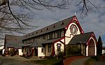
Naseby Street, Christchurch Merivale
Geographical coordinates (GPS) Address Nearby Places Show on map
 Continue reading on Wikipedia
 Geographical coordinates (GPS)
| Latitude | Longitude |
|---|---|
| N -43.517031 ° | E 172.616522 ° |
Address
Naseby Street 32
8014 Christchurch, Merivale
Canterbury, New Zealand
Open on Google Maps