Browne's Folly

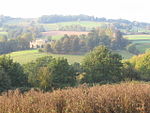
Brown's Folly or Brown's Folly (grid reference ST793662) is a folly tower sitting within a 39.9 hectare biological and geological Site of Special Scientific Interest (SSSI) near the village of Bathford in Somerset, notified in 1974: the site itself is known as the Farleigh (sometimes Farly) Down Stone Quarry, and is managed as a nature reserve by the Avon Wildlife Trust (AWT). The tower was built in 1848 and is a Grade II listed building.The site is situated on steep west-facing slopes which overlook the River Avon. The calcareous soils have developed on Lower Lias clays, fuller's earth and oolitic limestone strata of Jurassic age. The local geology is of major importance in the context of the British Bathonian stratigraphy.The site forms part of the Bath and Bradford-on-Avon Bats Special Area of Conservation and includes the remains of quarries used for the extraction of Bath Stone. These provide a rich variety of wildlife habitats. Downland flora has covered the spoilheaps where wild thyme, harebell and nine species of orchid (including the rare Fly Orchid) are found.: 252 Yellow Bird's-nest occurs here.: 108 The damp cliff faces support a variety of ferns, fungi and spiders. Pockets of ancient woodland on the lower slopes are home to woodpeckers, and unusual plants such as Bath asparagus.
Excerpt from the Wikipedia article Browne's Folly (License: CC BY-SA 3.0, Authors, Images).Browne's Folly
Prospect Place,
Geographical coordinates (GPS) Address External links Nearby Places Show on map
Geographical coordinates (GPS)
| Latitude | Longitude |
|---|---|
| N 51.39445 ° | E -2.29891 ° |
Address
Browne's Folly
Prospect Place
BA1 7TN
England, United Kingdom
Open on Google Maps


