The Pulpit (Washington)
Cascade RangeMount Baker-Snoqualmie National ForestMountains of King County, WashingtonNorth American 1000 m summits

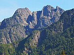
The Pulpit is a 4,523-foot (1,379-metre) mountain summit located in King County of Washington state. It's located at the western edge of the Cascade Range on land managed by Mount Baker-Snoqualmie National Forest. The Pulpit is more notable for its large, steep rise above local terrain than for its absolute elevation. The nearest higher peak is Preacher Mountain, 1.3 miles (2.1 km) to the southeast. Precipitation runoff from The Pulpit drains into tributaries of the Snoqualmie River.
Excerpt from the Wikipedia article The Pulpit (Washington) (License: CC BY-SA 3.0, Authors, Images).The Pulpit (Washington)
Geographical coordinates (GPS) Address Nearby Places Show on map
Geographical coordinates (GPS)
| Latitude | Longitude |
|---|---|
| N 47.521416 ° | E -121.551844 ° |
Address
King County
Washington, United States
Open on Google Maps


