place

Denmark Street

British popular musicEngvarB from July 2014Shopping streets in LondonStreets in the London Borough of Camden
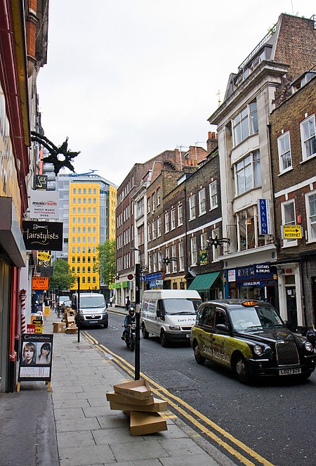
Denmark Street in 2010, by Martin Addison, geograph.org.uk 1957933

Denmark Street is a street on the edge of London's West End running from Charing Cross Road to St Giles High Street. It is near St Giles in the Fields Church and Tottenham Court Road station. The street was developed in the late 17th century and named after Prince George of Denmark. Since the 1950s it has been associated with British popular music, first via publishers and later by recording studios and music shops. A blue plaque was unveiled in 2014 commemorating the street's importance to the music industry. The street was originally residential, but became used for commercial purposes in the 19th century. At first, metalwork was a popular trade but it became most famous as Britain's "Tin Pan Alley" housing numerous music publishers' offices. This market declined in the 1960s to be replaced by music shops and independent recording studios. The Rolling Stones recorded at Regent Sound Studio at No. 4 and popular musicians, including David Bowie and the Small Faces, often socialised in the Gioconda café at No. 9. Elton John and Bernie Taupin wrote songs at offices on the street in the 1960s, while the Sex Pistols lived above No. 6, and recorded their first demos there. The comic book store Forbidden Planet and the Helter Skelter music bookshop have also been based on the street. In the 2010s, the surrounding area was redeveloped. Parts of Denmark Street are listed to protect them, but other parts, away from the street itself, are planned to be demolished.

Excerpt from the Wikipedia article Denmark Street (License: CC BY-SA 3.0, Authors, Images).

Denmark Street
Denmark Street, London Bloomsbury (London Borough of Camden)

Geographical coordinates (GPS) Address Nearby Places
placeShow on map

Wikipedia: Denmark StreetContinue reading on Wikipedia

Geographical coordinates (GPS)

Latitude Longitude
N 51.515277777778 ° E -0.12944444444444 °
placeShow on map

Address

Denmark Street 7
WC2H 8LX London, Bloomsbury (London Borough of Camden)
England, United Kingdom
mapOpen on Google Maps

Denmark Street in 2010, by Martin Addison, geograph.org.uk 1957933
Share experience

Nearby Places

Phoenix Garden
Phoenix Garden

The Phoenix Garden is a local community garden in central London, England, established in 1984. Located in St Giles behind the Phoenix Theatre, within the London Borough of Camden, the Phoenix Garden is nestled between the busy Soho and Covent Garden areas. The Garden is located just off St Giles Passage and Stacey Street, north of Shaftesbury Avenue and east of Charing Cross Road. The Garden was set up on a carpark in the 1980s, which had itself been established on a World War II bombsite (the site was bombed in 1940). Prior to this the Garden was the site of many houses, including a pub. The Phoenix Garden has survived various challenges, including a major industrial fly-tipping incident soon after its foundation. It is the only one of the original seven Covent Garden Community Gardens to survive to this day. The Phoenix Garden continues to be run by a committee of volunteers comprising local residents and workers. It is a registered charity (number 287502), and used to be known as the Covent Garden Open Spaces Association (CGOSA). The Garden has won first prize for Best Environmental Garden in the Camden in Bloom competition six times, from 2004 to 2010. It also holds regular social events, including an annual Agricultural Show and volunteering work-days. The garden was under threat of closure in 2016, and was closed for an 18-month renovation. It reopened in 2017 with an event space building designed by Office Sian. The garden is featured in the 2019 film Last Christmas.