place

Eagle Point (Olympic Mountains)

Landforms of Olympic National ParkMountains of Clallam County, WashingtonMountains of Washington (state)Olympic Mountains
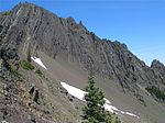
Eagle Point on Hurricane Ridge

Eagle Point is a 6,247 feet (1,904 m) summit in the Olympic Mountains and is located in Clallam County of Washington state. It is set on Hurricane Ridge within Olympic National Park. It's situated midway between Steeple Rock and Obstruction Peak, 1.42 mi (2.29 km) to the southeast. Precipitation runoff drains into tributaries of the Elwha River and Morse Creek, thence into the Strait of Juan de Fuca.

Excerpt from the Wikipedia article Eagle Point (Olympic Mountains) (License: CC BY-SA 3.0, Authors, Images).

Eagle Point (Olympic Mountains)
Eagle Point Trail,

Geographical coordinates (GPS) Address External links Nearby Places
placeShow on map

Wikipedia: Eagle Point (Olympic Mountains)Continue reading on Wikipedia

Geographical coordinates (GPS)

Latitude Longitude
N 47.939252 ° E -123.409067 °
placeShow on map

Address

Eagle Point Trail

Eagle Point Trail

Washington, United States
mapOpen on Google Maps

linkWikiData (Q49026677)
linkOpenStreetMap (269635227)

Eagle Point on Hurricane Ridge
Share experience

Nearby Places

Blue Mountain (Washington)

Blue Mountain is a 6,004-foot-elevation (1,830-meter) mountain summit located within Olympic National Park in Clallam County of Washington state. Blue Mountain is situated in the Daniel J. Evans Wilderness, 13 miles southeast of Port Angeles and 11 miles southwest of Sequim. Topographic relief is significant as the south aspect rises 4,000 feet (1,200 meters) above Gray Wolf River in approximately 2.5 miles. The mountain's name is due to a soft, blue haze that forms around the mountain in the summer. New settlers to the Olympic Peninsula near the end of the 19th century brought devastating fires started by land clearing and logging activities. The Dungeness Fire of 1891 burned about 30,000 acres, destroying much of the forest around Blue Mountain.Access is via the 19-mile Deer Park Road, and the summit can be reached by walking the half-mile Rain Shadow Loop Trail which gains 170 feet of elevation from road's end. The trail is so named because Blue Mountain lies within the rain shadow of the Olympic Mountains, receiving 50 inches of precipitation annually compared to more than 200 inches on Mount Olympus, 23 miles distant. Precipitation runoff from the mountain drains north to the Strait of Juan de Fuca via Maiden Creek, Siebert Creek, McDonald Creek, Canyon Creek, and Gray Wolf River. The summit offers a view of the San Juan Islands, Victoria across the strait on Vancouver Island, Canada, and on a clear day the eye can see as far as Mount Baker, 87 miles away. The endemic Olympic bellflower can be found near the summit.

Olympic National Park Headquarters Historic District

The Olympic National Park Headquarters Historic District overlooks Port Angeles, Washington from Peabody Heights, consisting of 6 contributing buildings built in 1940–44, 8 contributing structures and 17 non-contributing properties that act as the administrative headquarters for Olympic National Park. The contributing structures were built using locally obtained native materials in a late interpretation of the National Park Service Rustic style. Native landscaping enhances the site. Much of the work was carried out by Public Works Administration and Civilian Conservation Corps workers.The most significant building is the Administration Building (48°06′03″N 123°25′58″W), a two-story masonry and wood-frame structure with a long, horizontal design, emphasized by linear banding in the shingle cladding of the second story. The Custodian's Residence or Superintendent's Residence (48°06′03″N 123°25′53″W) housed the park superintendent until the 1980s when it was converted to offices. The irregularly shaped two-story building is similar in style and materials to the headquarters.A somewhat separated area comprises several maintenance buildings. The Gas and Oil House building (48°05′59″N 123°25′53″W) uses coursed stone and heavy timber, with a porte-cochere extending from the front to shelter gas pumps. The Transformer Vault and Pump House (48°05′59″N 123°25′59″W) is similar in character. The Equipment Shed/Carpenter Shop (48°05′58″N 123°25′55″W) is a stone and frame building in a saltbox shape with projecting bracketed eaves that anticipate the Mission 66 style structures on the 1950s and 1960s. The Equipment and Supply Building (48°05′57″N 123°25′54″W), measuring 199 feet (61 m) by 32 feet (9.8 m) is a masonry and frame building, with a large frame extension that burned in 1965. This section was replaced with a historically faithful copy in 1970.The Headquarters District is close to the park, but outside its primary boundaries. It was the first park headquarters to be situated outside its park. The district was placed on the National Register of Historic Places in 2007.