Hunger Hill, Lancashire
Geography of the Borough of West LancashireLancashire geography stubsUse British English from August 2018Villages in Lancashire

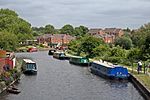
Hunger Hill is a small village three-quarters of a mile (1.2 km) from the centre of Wrightington, in West Lancashire, England. It is described as a rural settlement. It gets its name from the Second English Civil War when royalist soldiers stopped in the village for supplies.
Excerpt from the Wikipedia article Hunger Hill, Lancashire (License: CC BY-SA 3.0, Authors, Images).Hunger Hill, Lancashire
Mossy Lea Road, West Lancashire Wrightington
Geographical coordinates (GPS) Address Nearby Places Show on map
Geographical coordinates (GPS)
| Latitude | Longitude |
|---|---|
| N 53.596944444444 ° | E -2.6963888888889 ° |
Address
Mossy Lea Road
Mossy Lea Road
WN6 9RL West Lancashire, Wrightington
England, United Kingdom
Open on Google Maps


