Mahadevapura, Bangalore
Bangalore Urban district geography stubsNeighbourhoods in BangaloreUse Indian English from November 2018

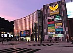
Mahadevapura is a suburb and one of the zones of BBMP in Bangalore Urban district in the Indian state of Karnataka. It was a city municipal council. It is well connected with Outer Ring Road, Whitefield Road and Krishnarajapuram Railway Station is the nearest station to board trains. It is a developing area, which has a high growth potential in terms of residential development. Leading schools, shopping malls, showrooms have come up in the area.
Excerpt from the Wikipedia article Mahadevapura, Bangalore (License: CC BY-SA 3.0, Authors, Images).Mahadevapura, Bangalore
Goshala Road, Bengaluru Garudachara Palya (Mahadevapura Zone)
Geographical coordinates (GPS) Address Nearby Places Show on map
 Continue reading on Wikipedia
 Geographical coordinates (GPS)
| Latitude | Longitude |
|---|---|
| N 12.99 ° | E 77.7 ° |
Address
Goshala Road
Goshala Road
560048 Bengaluru, Garudachara Palya (Mahadevapura Zone)
Karnataka, India
Open on Google Maps