place

Marl Lake

Bodies of water of Roscommon County, MichiganLakes of MichiganLower Peninsula, Michigan geography stubsProtected areas of Roscommon County, MichiganTourist attractions in Roscommon County, Michigan
Marl Lake, Michigan2

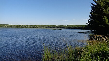
Marl Lake is a freshwater lake located in Roscommon County in the U.S. state of Michigan. The lake is entirety located within South Higgins Lake State Park. The lake is within Markey Township to the south and Gerrish Township to the north. Covering a surface area of 237 acres (0.96 km2), Marl Lake is a significantly smaller and less-developed lake compared to the nearby Higgins Lake. The two are connected by the Cut River, and upon exiting Marl Lake, the Cut River continues to flow into Houghton Lake. The lake can be reached through a state park access point along East Higgins Lake Road (County Road 100). The lake has a small public boat launch, but the use of electric or gas motors is restricted in favor of smaller vessels, as the lake itself is no more than 4 feet (1.2 m) deep. The waters may be difficult to fish due to its grassy nature and very loose marl bottom, but common fish within the lake include smallmouth bass, rock bass, sunfish, and several other small varieties. Other activities include hiking, biking, and cross-country skiing along the 5.5 miles (8.9 km) of trails cutting along and through the forest around Marl Lake. Kayaking, bird watching, photography, shore fishing, and picnicking are also popular activities.

Excerpt from the Wikipedia article Marl Lake (License: CC BY-SA 3.0, Authors, Images).

Marl Lake
Marl Lake Green Trail, Gerrish Township

Geographical coordinates (GPS) Address Nearby Places
placeShow on map

Wikipedia: Marl LakeContinue reading on Wikipedia

Geographical coordinates (GPS)

Latitude Longitude
N 44.4225 ° E -84.670277777778 °
placeShow on map

Address

Marl Lake Green Trail
Gerrish Township
Michigan, United States
mapOpen on Google Maps

Marl Lake, Michigan2
Share experience

Nearby Places

Higgins Lake
Higgins Lake

Higgins Lake is a large recreational and fishing lake in Roscommon County, in the U.S. state of Michigan. The 9,900 acres (4,000 ha) lake is known for its deep, clear waters and is the 10th largest in Michigan with a shoreline of 21 miles (34 km). It is named after Sylvester Higgins, the first chief of the topographical department of the Michigan Geological Survey. It has a maximum width of 4 miles (6.4 km) and a length of 7 miles (11 km) with a maximum depth of 135 feet (41 m). The mean depth is 135 feet (41 m) and the lake contains almost 20 billion cubic feet (570×10^6 m3) of water. Its retention time is about 12.5 years. The lake's watershed covers 19,000 acres (7,700 ha). The twin-lobed lake receives half of its water from submerged springs, six percent from incoming streams, and the remainder from direct rainfall and runoff. It drains into Marl Lake by the Cut River which runs into Houghton Lake and eventually to Lake Michigan via the Muskegon River. A mile north of the lake, water flows into the Lake Huron watershed. Sportfish in the lake include yellow perch, trout, smelt and pike. Fish are taken both in open water and by ice fishing. Higgins Lake is considered a morphometrically oligotrophic lake, meaning that its large size causes it to appear and function as a nutrient-poor lake although it receives a fair amount of nutrients. The unincorporated community of Higgins Lake is located along the western shores of the lake, and the lake is situated on the boundary between Lyon Township on the west and Gerrish Township on the east. There are two state parks, located on opposite ends of the lake: South Higgins Lake State Park, which has a mile of shoreline, and North Higgins Lake State Park. Both provide public boat launches and camping, and are very popular in the summer months. The south park is older, larger, and more developed. The north park is located on what was once the world's largest seedling nursery, a part of the Civilian Conservation Corps of the 1930s and early 1940s. Centuries before European settlers came to North America, the Chippewa people called the lake Majinabeesh, which means 'sparkling water'.

Houghton Lake (Michigan)

Houghton Lake is a lake in Roscommon County, Michigan. The unincorporated community of Prudenville is at the southeastern end of the lake, while the unincorporated communities of Houghton Lake and Houghton Lake Heights are on the southwest and west shores. It is the largest inland lake in the state of Michigan, and one of the largest natural inland lakes in the United States (many man-made impoundments are much larger). The lake is approximately 10 miles (16 km) north to south, and about 5+1⁄2 miles (8.9 km) at it widest point. Houghton Lake has c. 30 miles (48 km) of total shoreline and its waters cover 20,044 acres (81.12 km2). It is an extremely popular resort and fishing area year round. Houghton Lake is the site of Tip-Up-Town USA, a large ice fishing and winter sports festival with several events on the frozen waters of the lake itself. Houghton Lake is named after the first state geologist, Douglass Houghton who explored the area. Houghton County, in the Upper Peninsula of Michigan is also named after Douglass Houghton. The name of the lake is pronounced by Michigan citizens as "HOTE'n" (/ˈhoʊʔn̩/). The lake receives the waters of spring-fed Higgins Lake through the Cut River and, in turn, is the headwaters for the Muskegon River, which flows out of the North Bay in the northwest corner of the lake. The lake is partially within four townships: Markey Township on the northeast, Denton Township on the southeast, Roscommon Township on the southwest, and Lake Township on the northwest. The lake is mid to late mesotrophic in profile, and is considered to be a warm water, shallow lake, with the average depth being 7½ feet. The deepest spot is a small hole in East Bay that has been sounded to 22 feet (6.7 m), but it is rare to encounter depths of greater than 17 feet (5.2 m) in the lake. The lake offers almost every species of game and panfish found in Michigan with the exception of the trout/salmon families, the sturgeon, the muskellunge, and white bass. Common catches include northern pike, bluegill, walleye, crappie, yellow perch and both largemouth bass and smallmouth bass. M-55 follows the southern shore, while U.S. Highway 127 passes just to the west. M-18 and Interstate 75 pass just to the east. Houghton Lake is notable for the annual winter carnival, Tip Up Town USA, which is held during two consecutive weekends in January. The name for the festival originated from the flag-like devices - "tip-ups", used for ice fishing. The USA was added later. Tip Up Town Badges, required for entry to the Tip Up Town site on the south shore of Houghton Lake, are sold annually at local businesses. This carnival includes so many different activities. Prizes are won for different things for all different ages. There is the polar bear dip, where a hole of ice is cut out of the frozen lake, then the contestants jump in. Another famous attraction at Tip-Up Town is the ice slide. Weeks before the carnival starts, the effort is put in to make a giant slide made of nothing but ice! There are a lot of different races that happen on the lake as well. Side-by-side races, dirt bike races, and snowmobile races. The biggest attraction at Tip-Up Town is the beer tent. The beer tent is a big tent set up with live singers and drinks, it is the warmest place to visit. Houghton Lake is known for Tip-Up Town USA.