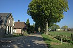
Ingen, Netherlands
BurenPopulated places in Gelderland

Ingen is a village in the Dutch province of Gelderland. It is a part of the municipality of Buren, and lies about 9 km south-west of Veenendaal. Before 1999 the town was part of the municipality of Lienden from 1818 till 1999. The houses are widely spread into a bowl form. The houses link to the townships De Ganzert and Eck en Wiel in the West.
Excerpt from the Wikipedia article Ingen, Netherlands (License: CC BY-SA 3.0, Authors, Images).Ingen, Netherlands
Luchtenburg, Buren
Geographical coordinates (GPS) Address Nearby Places Show on map
Geographical coordinates (GPS)
| Latitude | Longitude |
|---|---|
| N 51.966666666667 ° | E 5.4833333333333 ° |
Address
Luchtenburg
Luchtenburg
4031 KE Buren
Gelderland, Netherlands
Open on Google Maps


