Pfahl (Bavarian Forest)
Bavarian ForestCham (district)Geography of BavariaGeotopesRegen (district) ... and 1 more
Schwandorf (district)

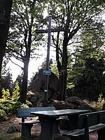
The Pfahl is a 150-kilometre-long quartz vein that runs through the northeastern Bavarian Forest in Germany. From a geomorphological point of view, it represents a residual ridge that has been formed by weathering and erosion over millions of years.
Excerpt from the Wikipedia article Pfahl (Bavarian Forest) (License: CC BY-SA 3.0, Authors, Images).Pfahl (Bavarian Forest)
B 85,
Geographical coordinates (GPS) Address Nearby Places Show on map
Geographical coordinates (GPS)
| Latitude | Longitude |
|---|---|
| N 49.083888888889 ° | E 12.86 ° |
Address
Großer Pfahl
B 85
94234
Bavaria, Germany
Open on Google Maps


