place

Compton Chamberlayne

Civil parishes in WiltshireEngvarB from July 2016OpenDomesdayVillages in Wiltshire
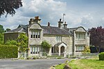
Compton Chamberlayne geograph.org.uk 329079

Compton Chamberlayne is a small village and civil parish in the Nadder Valley in south Wiltshire, England, about 7 miles (11 km) west of Salisbury. The Nadder forms the northern boundary of the parish; to the south are chalk hills. It is bisected by the A30 road. The village contains some 25 privately owned houses, a village hall, and a cricket pitch used by Compton Chamberlayne Cricket Club.

Excerpt from the Wikipedia article Compton Chamberlayne (License: CC BY-SA 3.0, Authors, Images).

Compton Chamberlayne
High Street,

Geographical coordinates (GPS) Address Nearby Places
placeShow on map

Wikipedia: Compton ChamberlayneContinue reading on Wikipedia

Geographical coordinates (GPS)

Latitude Longitude
N 51.069 ° E -1.96 °
placeShow on map

Address

High Street

High Street
SP3 5DA , Compton Chamberlayne
England, United Kingdom
mapOpen on Google Maps

Compton Chamberlayne geograph.org.uk 329079
Share experience

Nearby Places

Baverstock
Baverstock

Baverstock is a small village and former civil parish, now in the parish of Dinton, in Wiltshire, England, about 7 miles (11 km) west of Salisbury. The village has 10 private dwellings, a church and several farm buildings. The manor of Hurdcott, a hamlet of a few houses, lies to the southwest of the village (not to be confused with Hurdcott near Winterbourne Earls). In 1931 the parish had a population of 43. To the north of the village is cultivated chalk downland and extensive mixed woodland. To the south the village is bordered by the River Nadder meandering through water meadows. The road through the village from the B3089 terminates in unmetalled farm track. Baverstock civil parish was reduced in size when its southeast part, including Hurdcott hamlet, was transferred to Barford St Martin on 24 March 1884; the whole of Baverstock parish was absorbed into Dinton on 1 April 1934. The Church of England parish church of Saint Edith is dedicated to the Wiltshire saint Edith of Wilton and stands on the brow of a slope facing south across the Nadder valley. The building is from the 14th and 15th centuries, with restoration in 1880–1893 by William Butterfield. The building is Grade II* listed. The tower has a ring of three bells, two of which date from the 15th century. Today the church is part of the Nadder Valley team ministry. The churchyard contains, among others, the graves of 32 Australian soldiers from World War I. Soldiers were encamped locally before being transported to the war theatre in France. The majority died from infectious illness. Baverstock Manor is a Grade II* listed house from the 16th century, with later alterations and 1930s restoration. Close to the B3089 is the Penruddocke Arms, a public house named for the Penruddocke family who lived in neighbouring Compton Chamberlayne during the 18th and 19th centuries. North of the village lies Baverstock Juniper Bank, a 2.6 hectares (6.4 acres) biological Site of Special Scientific Interest at grid reference SU035336.

Chiselbury
Chiselbury

Chiselbury is the site of an Iron Age univallate hillfort in Wiltshire, England. The hillfort is sub-circular in plan, and encloses an area of approximately 10.5 acres (460,000 sq ft). It is defined by an earthen rampart up to 3.6 metres (12 ft) in height and an external ditch, up to a maximum of 1.6 metres (5.2 ft) in depth. A gap in the south-eastern side of the rampart, and a corresponding causeway across the ditch, is thought to be the original entrance and is associated with a small D-shaped embanked enclosure, which is apparently visible on aerial photographs. Although the enclosure has subsequently been degraded by ploughing, it is still apparent as a series of low earthworks.Limited archaeological investigation of the interior of the hillfort in the early 20th century failed to find any direct traces of occupation. However, outside of the fort some Iron Age pottery and a lead spindle whorl were found. In addition, two Roman coins, one of which dated to the reign of Emperor Constantine I, were said to have been found within the central area. An Iron Age sword and scabbard were also found on the nearby trackway which runs along the ridge top.The hillfort is abutted on both its northern and southern sides by embanked ditches or cross dykes. Their precise function is unknown but the manner in which they cut the ridge suggests that they were intended to prevent movement along it. The Northern Cross dyke, 90 metres (300 ft) in length, ran from the ditch of the hillfort across the top of the ridge before continuing part way down its northern slopes. Although visible in 1928, the section between the hillfort and the edge of the ridge has subsequently been infilled by ploughing, but survives as a buried feature. The Southern Cross dyke, which survives as a discontinuous series of banks and ditches, (sections of which are filled in but survive as buried features) is a total of 180 metres (590 ft) in length. It travels roughly south-south-east from the D-shaped enclosure, down the southern slope of the ridge, and into the base of a valley. An aerial photograph from 1928 clearly shows the southern cross dyke continuing as a buried feature beneath a trackway which runs along the ridge top, indicating that the trackway came into use after the cross dyke was constructed. An Anglo-Saxon charter also mentions 'the ridgeway' suggesting that the trackway was in use by at least the early medieval period. Referred to as the 'Ten Mile Course' by Dr. Stukeley in 1776, in the medieval and post-medieval periods the trackway was the main route from Wilton to Shaftesbury. By the 18th century it had become a turnpike road, and a map dated to 1773 depicts a toll house immediately to the south of it. The remains of the former toll house structure are visible today as a series of earthworks representing a building platform with a small enclosure immediately to its east.The site, including the cross dykes, is a scheduled monument.Today, the site is also known for the Fovant Badges, a number of regimental badges cut into the chalk of the hill on its northern flank. These were created by soldiers garrisoned near Fovant during the First World War, and are clearly visible from the A30 which runs through the village.

Gurston Down Motorsport Hillclimb

The Gurston Down Speed Hill Climb is a hillclimb in Broad Chalke, Wiltshire, England, organised by the South Western Centre of the British Automobile Racing Club. The first practice meeting was held on 25 June 1967, when Patsy Burt, driving a McLaren-Oldsmobile set a time of 39.90 sec. The first competition event was held on 23 July 1967. The track currently hosts eight competitive events each year; two, two-day events, and five are single-day events. In addition, a Test Day is held annually just before the competitive season starts. The venue also conducts four Hill Climb School days each year, which follow the syllabus set by AHASS (the Association of Hill Climb and Sprint Schools). The venue currently hosts two rounds a year of the British Hill Climb Championship during May and August and seven events of its own championship. The 2020 Hill and Championship Sponsor is Turbo Dynamics, a company owned and run by Peter Marsh, son of the hill's designer, Tony Marsh. In addition to the Turbo Dynamics Championship, the venue hosts rounds of the ASWMC, ACSMC and HSA championships and a number of other national championships. Motorcycles also visit the venue five times a year, and run as part of five of the single-day events. The motorcycle riders are members of the National Hill Climb Association (NHCA). The farmland the course traverses is also used for pheasant shoots and the course itself has found a dual use as a gravity racing venue. The course measures 1058 yards (967 metres), and rises a total of 140 feet (43 metres), although the first section of the track is downhill, a feature unique in British hill climbing, but not unknown elsewhere in Europe. The course was designed in 1965 by Tony Marsh, who was still competing the course in the premier over 2000cc racing car class in 2007. In July 2009, the third round of the Gurston Down Speed Hill Climb Championships was dedicated to Marsh's memory following his death in May.The outright hill record is held by Wallace Menzies, who completed the course in 25.34 seconds on 30 May 2021.