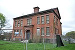
Upper Albany Historic District
Colonial Revival architecture in ConnecticutHistoric districts on the National Register of Historic Places in ConnecticutNational Register of Historic Places in Hartford, ConnecticutQueen Anne architecture in ConnecticutShingle Style architecture in Connecticut

The Upper Albany Historic District encompasses a predominantly residential area of the North End of Hartford, Connecticut. It extends along Albany Avenue (United States Route 44) between Garden and Woodland Streets, including side streets to the south, and extends northward to include the southern portion of Keney Park. This area was developed in the first two decades of the 20th century, and has a fine array of period middle-class housing in the Queen Anne and Colonial Revival styles. It was listed on the National Register of Historic Places in 1986.
Excerpt from the Wikipedia article Upper Albany Historic District (License: CC BY-SA 3.0, Authors, Images).Upper Albany Historic District
Edgewood Street, Hartford
Geographical coordinates (GPS) Address Nearby Places Show on map
Geographical coordinates (GPS)
| Latitude | Longitude |
|---|---|
| N 41.785833333333 ° | E -72.690555555556 ° |
Address
Edgewood Street 260
06112 Hartford
Connecticut, United States
Open on Google Maps


