Seulingswald
Central UplandsEast HesseForests and woodlands of ThuringiaHersfeld-RotenburgMountain ranges of Thuringia ... and 3 more
Natural regions of the East Hesse HighlandsRegions of HesseWartburgkreis

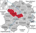
The Seulingswald (also called the Sillingswald) is a hill range in the German Central Uplands which reaches heights of up to 480.3 m above sea level (NHN). It is part of the Fulda-Werra Uplands in the East Hesse Highlands within the Hessian county of Hersfeld-Rotenburg; small ridges extend into the Thuringian county of Wartburgkreis. It is a sandstone range and one of the largest contiguous woodland areas in Hesse.
Excerpt from the Wikipedia article Seulingswald (License: CC BY-SA 3.0, Authors, Images).Seulingswald
A 4, Friedewald
Geographical coordinates (GPS) Address Nearby Places Show on map
Geographical coordinates (GPS)
| Latitude | Longitude |
|---|---|
| N 50.900277777778 ° | E 9.8389166666667 ° |
Address
A 4
36289 Friedewald
Hesse, Germany
Open on Google Maps


