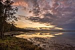
Gorokan, New South Wales

Gorokan is a suburb of the Central Coast region of New South Wales, Australia. It is part of the Central Coast Council local government area. The word "Gorokan" means "The Morning Dawn" from the language of the Awabakal (an Aboriginal tribe). There are two schools in the area, Gorokan Public School and Gorokan High School. Electricity was first brought to the area as a part of a £42,000 programme for electricity reticulation under the Brisbane Water County Council. Located on the shores of Lake Tuggerah, Gorokan has long been a holiday destination with the Quoy family first buying land in the area in 1923 where they built and rented a series of holiday homes. Other families such as the Gedlings (by way of Gordon and Margaret Gedling) built a holiday house on the Gorokan waterfront in 1956.
Excerpt from the Wikipedia article Gorokan, New South Wales (License: CC BY-SA 3.0, Authors, Images).Gorokan, New South Wales
The Corso, Central Coast Council
Geographical coordinates (GPS) Address Nearby Places Show on map
Geographical coordinates (GPS)
| Latitude | Longitude |
|---|---|
| N -33.257 ° | E 151.518 ° |
Address
The Corso
The Corso
2263 Central Coast Council, Gorokan
New South Wales, Australia
Open on Google Maps


