place

Queen Katherine Street drill hall, Kendal

Buildings and structures in CumbriaDrill halls in EnglandKendalUse British English from June 2017
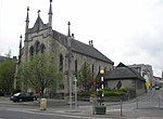
Former World War One Drill Hall, Kendal geograph.org.uk 4185070

The Queen Katherine Street drill hall, sometimes known as the Aynam Road drill hall is a military installation located in Queen Katherine Street, off Aynam Road, in Kendal, Cumbria, England.

Excerpt from the Wikipedia article Queen Katherine Street drill hall, Kendal (License: CC BY-SA 3.0, Authors, Images).

Queen Katherine Street drill hall, Kendal
Queen Katherine Street,

Geographical coordinates (GPS) Address Nearby Places
placeShow on map

Wikipedia: Queen Katherine Street drill hall, KendalContinue reading on Wikipedia

Geographical coordinates (GPS)

Latitude Longitude
N 54.32475 ° E -2.74297 °
placeShow on map

Address

Queen Katherine Street

Queen Katherine Street
LA9 7DG , Netherfield
England, United Kingdom
mapOpen on Google Maps

Former World War One Drill Hall, Kendal geograph.org.uk 4185070
Share experience

Nearby Places

Quaker Tapestry

The Quaker Tapestry consists of 77 panels illustrating the history of Quakerism from the 17th century to the present day. The idea of Quaker Anne Wynn-Wilson, the tapestry has a permanent home at the Friends Meeting House at Kendal, Cumbria, England. The design was heavily influenced by the Bayeux Tapestry, and includes similar design choices, including three horizontal divisions within panels, embroidered outlines for faces and hands, and solid infilling of clothing, which is embroidered in the Bayeux technique. The tapestry is worked in crewel embroidery using woollen yarns on a handwoven woollen background. In addition to using four historic and well-known stitches (split stitch, stem stitch, chain stitch and Peking knot), Wynn-Wilson invented a new corded stitch, known as Quaker stitch, to allow for tight curves on the lettering. Each panel measures 25 inches (64 cm) wide by 21 inches (53 cm) tall. 4,000 men, women and children from 15 countries worked on the panels between 1981 and 1989. Panels have been toured in traveling exhibitions including a North American tour in 1993/1994. An exhibition of 39 panels in Ely Cathedral in 2012 attracted 11,273 visitors during its 27-day stay. Although the content of all 77 panels is widely published, only around 40 are on display at any one time, and close observers have noted that 23 have never been seen in public. This has led to some speculation in avant garde embroidery circles that the content may actually be transgressive in nature.In October 2021, the museum was one of 142 sites across England to receive part of a £35-million injection into the government's Culture Recovery Fund.

Barony of Kendal
Barony of Kendal

The Barony of Kendal is a subdivision of the English historic county of Westmorland. It is one of two ancient baronies that make up the county, the other being the Barony of Westmorland (also known as North Westmorland, or the Barony of Appleby). In 1974, the entire county became part of the modern county of Cumbria and ceased to have an administrative function. At the same time, Kendal borough along with some other rural and urban districts in Westmorland was merged with the neighbouring parts of Lancashire, Furness and Cartmel, and also the Sedbergh Rural District of the West Riding of Yorkshire into the new South Lakeland district of the new county. The barony is the remnant of the feudal barony whose caput was at Kendal castle. The feudal barony had its own complex evolution, determined by the evolution of the families that owned it. For some purposes, it was therefore once considered to include parts of the Barony of Westmorland that were possessed by the original lords of Kendal, such as at least parts of the ancient parishes of Barton St Michael, and Morland. In modern times, before it was scrapped, the barony came to be divided into two administrative wards, Kendal and Lonsdale, centred on the old church towns of Kendal (sometimes referred to historically as Kirkby Kendal), and Kirkby Lonsdale, which are respectively geographically centred on the valleys ("dales") of the rivers Kent and Lune. The parishes of the two wards are as follows: Kendal ward: Ambleside, Burton-in-Kendal, Grasmere, Grayrigg, Kentmere, Kendal, Windermere. (The parish of Kendal itself was large and contained 20 townships.) Lonsdale ward: Kirkby Lonsdale