Cracroft Reserve

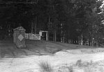
Cracroft Reserve is a 3.2-hectare (7.9-acre) public reserve on Cracroft Hill in the Cashmere suburb of Christchurch, New Zealand. It is situated next to the Sign of the Takahe. Cracroft Reserve is a popular stop for tourists, and residents, with its viewing platform at 200 metres (660 ft) elevation providing panoramic views of Christchurch city, the Canterbury Plains, and the Southern Alps. The main entrance to the reserve is from the southern end of Hackthorne Road. The reserve features a sturdy stainless steel plane table pointing to a wide range of landmarks visible from Cracroft Reserve, from Aoraki / Mount Cook to the south to Mount Tapuaenuku to the north. This sign, set on a Halswell stone base, was erected by the Rotary Club of Christchurch in 1967.Cracroft Reserve is named after John Cracroft Wilson. Cracroft Wilson sold the property, once part of the larger Cashmere farm, to the city in about 1925, as part of prominent local politician Harry Ell's initiative to establish a network of reserves, rest houses, and tracks through the Christchurch Port Hills.
Excerpt from the Wikipedia article Cracroft Reserve (License: CC BY-SA 3.0, Authors, Images).Cracroft Reserve
Hackthorne Road, Spreydon-Cashmere Community Cashmere
Geographical coordinates (GPS) Address Nearby Places Show on map
 Continue reading on Wikipedia
 Geographical coordinates (GPS)
| Latitude | Longitude |
|---|---|
| N -43.580111111111 ° | E 172.63438888889 ° |
Address
Cashmere Scout Hall
Hackthorne Road
8022 Spreydon-Cashmere Community, Cashmere
Canterbury, New Zealand
Open on Google Maps