Saint-Hubert, Quebec

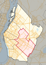
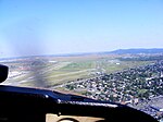
Saint-Hubert ( - HEW-bərt, French pronunciation: [sɛ̃t‿ybɛʁ] , locally [sẽɪ̯̃t͡s‿ybaɛ̯ʁ]) is a borough in the city of Longueuil, located in the Montérégie region of Quebec, Canada. It had been a separate city prior to January 1, 2002, when it along with several other neighbouring south shore municipalities were merged into Longueuil. Saint-Hubert had a population of 78,336 in 2006. The area of the borough is 65.98 km2 (25.48 sq mi). Longueuil's city hall is now located in Saint-Hubert. Saint-Hubert is located about 14 kilometres (8.7 mi) from downtown Montreal. The borough has a wide array of commercial, industrial and agricultural enterprises. The aerospace industry is arguably the most important of these enterprises. Pratt & Whitney Canada designs and manufactures jet engines at a plant near Saint-Hubert Airport. The Canadian Space Agency has its head office in the borough. The École nationale d'aérotechnique, a school that teaches aeronautics is located in the borough and operated by Collège Édouard-Montpetit.
Excerpt from the Wikipedia article Saint-Hubert, Quebec (License: CC BY-SA 3.0, Authors, Images).Saint-Hubert, Quebec
Boulevard Gaétan-Boucher, Longueuil
Geographical coordinates (GPS) Address Nearby Places Show on map
Geographical coordinates (GPS)
| Latitude | Longitude |
|---|---|
| N 45.4825 ° | E -73.419722222222 ° |
Address
Boulevard Gaétan-Boucher
Boulevard Gaétan-Boucher
J3Y 2T4 Longueuil
Quebec, Canada
Open on Google Maps


