place

Glostrup station

Buildings and structures in Glostrup MunicipalityCopenhagen Metro stubsDanish railway station stubsHeinrich Wenck buildingsRailway stations in Denmark opened in 1847
S-train (Copenhagen) stationsTransport infrastructure completed in 1918
Glostrup Station
Glostrup Station

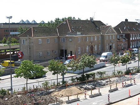
Glostrup station is a commuter rail railway station serving the railway town/suburb of Glostrup west of Copenhagen, Denmark. It is located on the Høje Taastrup radial of Copenhagen's S-train network. It is located close to the historical, administrative and commercial centre of Glostrup Municipality, but also serves Brøndbyvester in Brøndby Municipality, whose boundary comes within a few hundred metres from the station. In front of the station is a major bus terminal from which local and express buses go in many directions. The station is connected to the nearby Glostrup Shopping Center via an underground walkway, the same walkway which is used to access the platforms. Glostup is one of the few remaining stations in Copenhagen that is an active rail freight destination. Sidings to industries west, south, and east of the station emerge from a small freight yard south of the long-distance tracks.

Excerpt from the Wikipedia article Glostrup station (License: CC BY-SA 3.0, Authors, Images).

Glostrup station
Banegårdspladsen, Glostrup Municipality

Geographical coordinates (GPS) Address Nearby Places
placeShow on map

Wikipedia: Glostrup stationContinue reading on Wikipedia

Geographical coordinates (GPS)

Latitude Longitude
N 55.662916666667 ° E 12.397222222222 °
placeShow on map

Address

Banegårdspladsen 11
2600 Glostrup Municipality
Capital Region of Denmark, Denmark
mapOpen on Google Maps

Glostrup Station
Glostrup Station
Share experience

Nearby Places

Glostrup Municipality

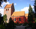
Glostrup Kommune is a suburban municipality (Danish kommune) and town in Region Hovedstaden on the island of Zealand (Sjælland) approx. 10 km west of Copenhagen in eastern Denmark. The municipality covers an area of 13.31 km², and has a total population of 23,635 (2023). Its Zip code (Postnummer) is 2600. Its mayor as of 2022 is Kasper Damsgaard, a member of the Social Democrats (Socialdemokratiet) political party. The municipality was established in 1841 following the municipal reforms of the 1840s, ranking as a parish municipality (sognekommune) until 1950 when suburbanisation of Copenhagen inhabited the municipality and the status was changed to town municipality (købstadskommune). From 1947 to 1960 the population in the municipality doubled due to the expanding suburbs of Copenhagen, reaching the municipality in the post-war period. Glostrup was designated as a new suburb along the western Tåstrup-finger of the Copenhagen Finger Plan of 1947. The main town and the site of its municipal council is the town of Glostrup, home to three quarters of the population. Other towns in the municipality are Hvissinge and Ejby. Until 1974 the town of Avedøre also belonged to this municipality. Being an exclave, it was merged into the neighbouring Hvidovre Municipality. Neighboring municipalities are Rødovre to the east, Herlev and Ballerup to the north, Albertslund to the west, and Brøndby to the south. Glostrup was not merged with other municipalities on 1 January 2007, as the result of nationwide Kommunalreformen ("The Municipality Reform" of 2007). The church of Glostrup originates from the 12th century.

Rigshospitalet Glostrup

Rigshospitalet Glostrup is hospital located in the township of Glostrup, 8 km from the center of Copenhagen in Denmark. It is owned and managed by the regional health authority of the Greater Copenhagen region, Region Hovedstaden. The hospital was formerly known as Glostrup Hospital, but after the merger with Rigshospitalet 1/1/2015, it is now known as Rigshospitalet Glostrup. A teaching hospital for students of multiple vocations, Rigshospitalet Glostrup is affiliated with the University of Copenhagen and more than 200 of its employees hold academic posts at the university, including 14 professorial chairs. It is the primary hospital for the 165,000 citizens of the townships of Albertslund, Ishøj, Høje-Taastrup, Glostrup, and Vallensbæk and as a secondary referral center for larger parts of Region Hovedstaden in neurosurgery, clinical neurophysiology, neurology, and occupational medicine. Several high-profiled subspecialized clinical centers with research activities are incorporated in the departments of the Glostrup Hospital, including the Danish Headache Center. Annual visits number 230,000 patients, including 40,000 in-patients, and 18,000 surgical procedures. With 3,200 employees, 512 beds, Eastern Denmark's largest emergency department and the country's largest ophthalmology department, the Glostrup Hospital is currently undergoing expansion and reorganization to make it a regional and national center in selected specialties while continuing to serve the local community as a general hospital. Architecturally, Rigshospitalet Glostrup is renowned as an example of new public institutions built in the first decades after World War II. Built from the ground in 1952-1958 after an international competition won by architects Martta Martikainen-Ypyä, Ragnar Ypyä, and Veikko Malmio, the hospital was officially inaugurated September 2, 1958 by king Frederick IX of Denmark.

Vestegnen
Vestegnen

Vestegnen is a term for a part of the former Copenhagen County, located west of Copenhagen. The area is defined as consisting of the municipalities of Rødovre, Hvidovre, Glostrup, Brøndby, Albertslund, Vallensbæk, Herlev, Ishøj and Høje-Taastrup and covers the area around some of the stations of the S-train, which are on the lines towards Høje Taastrup and Køge, and which are within the former Copenhagen County. The urban area of Hundige is often included due to its proximity to the rest of “Vestegnen” and the former terminus on the Køge Bugt-banen, but Hundige is located in Greve Municipality and thus neither in the former Copenhagen County nor the current Capital Region of Denmark. Common to the mentioned municipalities – except Vallensbæk Municipality – is that they have for long periods been led by mayors of Socialdemokratiet – in several cases with an absolute majority in the municipal council.The municipalities covered by the former Vestegnssamarbejde (Rødovre, Hvidovre, Glostrup, Brøndby, Albertslund, Vallensbæk, Ishøj and Høje-Taastrup) has a total population of 229,090 people, of which approximately 26.7% have an ethnic background other than Danish, as per 2018. This is more than twice as high as the national average of 13%. In Brøndby Strand, the number of people with other ethnic background than Danish was the highest, with 51%. Around 108,000 of the inhabitants are part of the labour force, but in the area there are around 136,000 jobs.Vestegnen also has a common history that is reminiscent of, or coincides with, Hedeboegnen – the area bounded by Køge Å in the south and Værebro Å in the north. Just as agriculture came to the area early, it disappeared late, and the villages remained as the primary settlement until World War II. Thereafter, the area was expanded rapidly to accommodate the growing and increasingly affluent population in the Capital Region of Denmark. Vestegnen is therefore characterised by very little forested area, except for Vestskoven, which was artificially created in 1967, and large areas with modern housing in which many of the old villages still exist. Since the area was agricultural land right up until World War II, there is not much old industry either – most industrial districts are from the 1960s, 70s or 80s.