So Kwun Wat
Populated places in Hong KongSo Kwun WatTuen Mun District

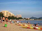
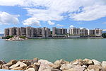
So Kwun Wat, commonly pronounced So Kwun Fat, is an area on the south coast of the western mainland New Territories in Hong Kong. The proper So Kwun Wat is a populated area in the valley between Siu Lam and Sam Shing Hui. It includes So Kwun Tan (掃管灘) on the shore, which is a residential area, Hong Kong Gold Coast (香港黃金海岸), with villas on Pearl Island (龍珠島) off the coast. Administratively, the area belongs to Tuen Mun District. Northwest of So Kwun Tan is the Perowne Camp (寶龍軍營 or 掃管軍營).
Excerpt from the Wikipedia article So Kwun Wat (License: CC BY-SA 3.0, Authors, Images).So Kwun Wat
So Kwun Wat Road, Tuen Mun District So Kwun Wat
Geographical coordinates (GPS) Address Nearby Places Show on map
 Continue reading on Wikipedia
 Geographical coordinates (GPS)
| Latitude | Longitude |
|---|---|
| N 22.375 ° | E 114.001 ° |
Address
第3座 Tower 3
So Kwun Wat Road
Tuen Mun District, So Kwun Wat
Hong Kong, China
Open on Google Maps