Electoral district of Ninderry
Electoral districts of QueenslandUse Australian English from April 2020
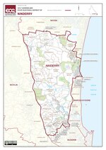
Ninderry is an electoral district of the Legislative Assembly in the Australian state of Queensland. It was created in the 2017 redistribution.Located in the Sunshine Coast, Ninderry consists of the suburbs of Eumundi, Doonan, Weyba Downs, Peregian Beach, Peregian Springs, Verrierdale, North Arm, Ninderry, Valdora, Yandina, Yandina Creek, Coolum Beach, Maroochy River, Parklands, Bli Bli, Rosemount, Diddillibah, Kiels Mountain, Kunda Park, Kuluin, Forest Glen, Mons and "North Buderim".From results of the 2015 election, Ninderry was estimated to be a fairly safe seat for the Liberal National Party with a margin of 6.9%.
Excerpt from the Wikipedia article Electoral district of Ninderry (License: CC BY-SA 3.0, Authors, Images).Electoral district of Ninderry
Sunshine Coast Regional
Geographical coordinates (GPS) Address Nearby Places Show on map
 Continue reading on Wikipedia
 Geographical coordinates (GPS)
| Latitude | Longitude |
|---|---|
| N -26.5486 ° | E 153.0134 ° |
Address
Sunshine Coast Regional (Valdora)
Queensland, Australia
Open on Google Maps


