Liberation of Arnhem

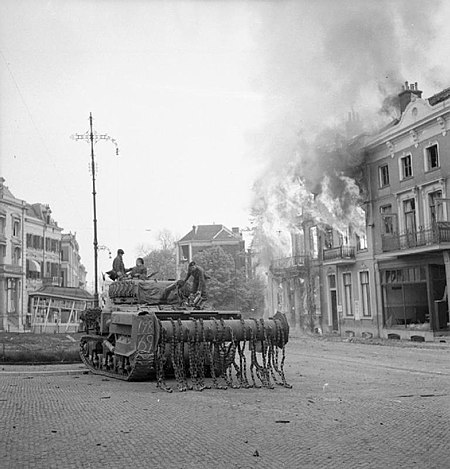
Operation Anger (sometimes known as Operation Quick Anger) was a military operation to seize the city of Arnhem in April 1945, during the closing stages of the Second World War. It is also known as the Second Battle of Arnhem or the Liberation of Arnhem. The operation was part of the Canadian First Army's liberation of the Netherlands and was led by the 49th British Infantry Division, supported by armour of the 5th Canadian Armoured Division, Royal Air Force air strikes and boats of the Royal Navy. The Western Allies first tried to liberate Arnhem in September 1944 during Operation Market Garden. Poor planning, the unexpected presence of German armoured units and a delayed advance by ground forces meant that the 1st British Airborne Division were defeated and a new front stabilised south of the city. Fresh planning to take Arnhem began in the new year as the Canadian First Army sought ways to link up its units advancing into the Netherlands. However it was not until April that the liberation of the city became a distinct possibility. After II Canadian Corps secured the eastern bank of the IJssel river and advanced north, I Canadian Corps prepared to assault Arnhem. The operation began on 12 April 1945 and proceeded to plan, as the three infantry brigades of the 49th Division leapfrogged each other through the city. Within four days Arnhem was totally under Allied control, allowing the Canadians to advance further into the Netherlands. Less than two weeks after the battle a general truce brought major combat operations in the country to an end and on 5 May the German commander in chief in the Netherlands surrendered to the Canadian Army. Three days later Germany unconditionally surrendered, bringing the war in Europe to a close.
Excerpt from the Wikipedia article Liberation of Arnhem (License: CC BY-SA 3.0, Authors, Images).Liberation of Arnhem
Jansbinnensingel, Arnhem
Geographical coordinates (GPS) Address Nearby Places Show on map
Geographical coordinates (GPS)
| Latitude | Longitude |
|---|---|
| N 51.984444444444 ° | E 5.91 ° |
Address
Jansbinnensingel
6811 AK Arnhem
Gelderland, Netherlands
Open on Google Maps


