Rancho Cucamonga
California Historical LandmarksCalifornia ranchosGeography of Rancho Cucamonga, CaliforniaRanchos of San Bernardino County, California

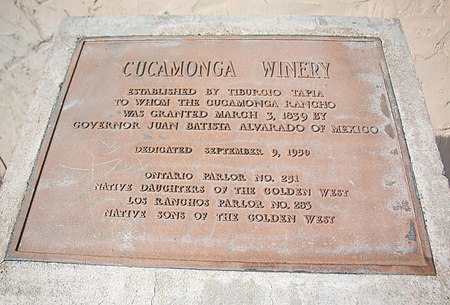
Rancho Cucamonga was a 13,045-acre (20.383 sq mi; 52.79 km2) Mexican land grant in present-day San Bernardino County, California, given in 1839 to the dedicated soldier, smuggler and politician Tiburcio Tapia by Mexican governor Juan Bautista Alvarado. The grant formed parts of present-day California cities Rancho Cucamonga and Upland. It extended easterly from San Antonio Creek to what is now Hermosa Avenue, and from today's Eighth Street to the mountains.
Excerpt from the Wikipedia article Rancho Cucamonga (License: CC BY-SA 3.0, Authors, Images).Rancho Cucamonga
Foothill Boulevard, Rancho Cucamonga
Geographical coordinates (GPS) Address Nearby Places Show on map
Geographical coordinates (GPS)
| Latitude | Longitude |
|---|---|
| N 34.106683 ° | E -117.6107 ° |
Address
Klatch Coffee
Foothill Boulevard 8916
91730 Rancho Cucamonga
California, United States
Open on Google Maps


