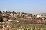
Khirbet Beit Zakariyyah
Bethlehem GovernorateMunicipalities of the State of PalestineSeam ZoneVillages in the West Bank

Khirbet Beit Zakariyyah (variants: Beit Iskâria, Khirbet Zakariah, Beit Skâria) is a small Palestinian village southwest of Bethlehem in the West Bank, perched on a hill that rises about 995 metres (3,264 ft) above sea level. Administratively, it is associated with the village of Artas under the Bethlehem Governorate. It is also located in between the Israeli settlements of Alon Shevut and Rosh Tzurim, both of which were built on land confiscated from the village.
Excerpt from the Wikipedia article Khirbet Beit Zakariyyah (License: CC BY-SA 3.0, Authors, Images).Khirbet Beit Zakariyyah
Beitar Ilit
Geographical coordinates (GPS) Address Nearby Places Show on map
Geographical coordinates (GPS)
| Latitude | Longitude |
|---|---|
| N 31.663055555556 ° | E 35.123333333333 ° |
Address
Beitar Ilit
Judea and Samaria, Palestinian Territories
Open on Google Maps


