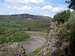
Wyndcliff

The Wyndcliff or Wynd Cliff (historically sometimes spelt Wyndcliffe) is a steep limestone cliff rising above the western bank of the River Wye in Monmouthshire, Wales, some 1 mile (1.6 km) north-east of the village of St Arvans, 2.5 miles (4.0 km) south of Tintern, and 3.5 miles (5.6 km) north of the town of Chepstow, within the Wye Valley Area of Outstanding Natural Beauty. The cliff rises to 771 feet (235 m) at its summit, the highest point on the Monmouthshire bank of the Wye. The area is traversed by the Wye Valley Walk, and is also a popular venue for rock climbing. Access is provided by the A466 road which passes along the valley immediately below the cliff face. The site has been appreciated by visitors since the time of the Wye Tour in the late eighteenth and early nineteenth centuries. It contains several viewing points constructed so that visitors can gain a full appreciation of the area's Picturesque landscape, including the Eagle's Nest viewpoint which was built in 1828 for its landowner the Duke of Beaufort as an extension to the walking path network already developed around the nearby Piercefield estate. It has been described as "one of the most impressive viewpoints in the British Isles".
Excerpt from the Wikipedia article Wyndcliff (License: CC BY-SA 3.0, Authors, Images).Wyndcliff
365 Steps,
Geographical coordinates (GPS) Address Nearby Places Show on map
Geographical coordinates (GPS)
| Latitude | Longitude |
|---|---|
| N 51.6736 ° | E -2.6828 ° |
Address
Cardiac
365 Steps
NP16 6HD , St Arvans
Wales, United Kingdom
Open on Google Maps


