Pelaw
GatesheadGeography of Tyne and Wear
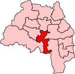
Pelaw () is a residential area in Gateshead, located around 3.5 miles (5.6 km) from Newcastle upon Tyne, 11 miles (18 km) from Sunderland, and 17 miles (27 km) from Durham. In 2011, Census data for the Gateshead Metropolitan Borough Council ward of Heworth and Pelaw recorded a total population of 9,100.Pelaw lies in between the older settlements of Heworth to the west, Bill Quay to the east, and Wardley to the south, with the southern bank of the River Tyne forming the northern border.
Excerpt from the Wikipedia article Pelaw (License: CC BY-SA 3.0, Authors).Pelaw
Keir Hardie Avenue,
Geographical coordinates (GPS) Address Phone number Website Nearby Places Show on map
Geographical coordinates (GPS)
| Latitude | Longitude |
|---|---|
| N 54.95 ° | E -1.54 ° |
Address
Wardley Primary School
Keir Hardie Avenue
NE10 8TX , Wardley
England, United Kingdom
Open on Google Maps


