place

Buckfast

BuckfastleighDevon geography stubsVillages in Devon
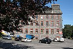
Buckfast Abbey and Methodist Chapel geograph.org.uk 1249287

Buckfast is a small village near Buckfastleigh in Teignbridge district, Devon, England, on the bank of the River Dart. It is the home of Buckfast Abbey, an active Benedictine monastery, which gave its name to Buckfast Tonic Wine, originally made there, and to the Buckfast bee, a bee breed originally developed at Buckfast Abbey. Buckfast is in the civil parish of Buckfastleigh, which has a town council.There is a Methodist chapel, built in 1881, which is used for joint Anglican and Methodist services every Sunday.The village has a co-educational Roman Catholic primary school, St Mary's Catholic Primary School.There were woollen mills in the village, powered by the River Dart. A large mill was taken over in the 1950s by Axminster Carpets. When the company went into administration in 2013 the Abbey acquired the Mill premises.The village has a post office, which relocated in 2015 into the Mill Shop.

Excerpt from the Wikipedia article Buckfast (License: CC BY-SA 3.0, Authors, Images).

Buckfast
Higher Mill Lane, Teignbridge Buckfastleigh

Geographical coordinates (GPS) Address Nearby Places
placeShow on map

Wikipedia: BuckfastContinue reading on Wikipedia

Geographical coordinates (GPS)

Latitude Longitude
N 50.4923 ° E -3.77903 °
placeShow on map

Address

Higher Mill Lane

Higher Mill Lane
TQ11 0EN Teignbridge, Buckfastleigh
England, United Kingdom
mapOpen on Google Maps

Buckfast Abbey and Methodist Chapel geograph.org.uk 1249287
Share experience

Nearby Places

Hembury Castle, Buckfast

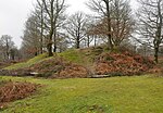
Hembury Castle is an Iron Age hillfort about a mile north-west of the village of Buckfast on the south-eastern edge of Dartmoor in Devon, England (grid reference SX726684). The fort is about 178 metres above sea level on a promontory between the River Dart on the east and the Holy Brook, south-west. The slope down to the River Dart is very steep and is covered by Hembury Woods which is now a Site of Special Scientific Interest.The fort is said to cover about seven acres and it is surrounded by a prominent rampart and ditch. It is one of several Iron Age forts on the eastern edge of Dartmoor, others include Holne Chase Castle, Wooston Castle, Cranbrook Castle and Prestonbury Castle. Inside the fort, on the western side, is an 11th- or 12th-century motte with a surrounding narrow inner bailey. The ramparts of the earlier hillfort may have been used as the outer bailey of the castle. The entire site has legal protection as a scheduled monument.The first documentary reference to Hembury Castle is in the 13th-century cartulary of nearby Buckfast Abbey, where it is referred to as vetus castellum quod dicitur Hembire. The name probably derives from Old English hean byrig, "at the high burh".A legend relates that the fort was held by the Danes, but it was taken from them by a stratagem. Some local women allowed themselves to be captured by the Danes and taken into the fort, but in the night when their captors were in a drunken sleep, the women rose, killed them and let in their countrymen.