Roman camp, Marktbreit
1985 archaeological discoveriesBuildings and structures in Kitzingen (district)Heritage sites in BavariaPopulated places disestablished in the 1st centuryPopulated places established in the 1st century ... and 3 more
Portal templates with redlinked portalsRoman fortifications in Germania SuperiorRoman fortified camps in Germany

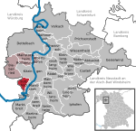
The Roman camp at Marktbreit (German: Römerlager Marktbreit) is a castrum (Roman legionary fortification) with a nearby canabae from the period of Emperor Augustus. It is located in the municipal territory of the Lower Franconian town of Marktbreit on the left bank of the River Main, in the district of Kitzingen inside the German state of Bavaria. It is remarkable because until 1985 it was never suspected that a legionary fortress was built by the Romans so far east in Germanic enemy territory.
Excerpt from the Wikipedia article Roman camp, Marktbreit (License: CC BY-SA 3.0, Authors, Images).Roman camp, Marktbreit
Mainleite, Marktbreit (VGem)
Geographical coordinates (GPS) Address Nearby Places Show on map
Geographical coordinates (GPS)
| Latitude | Longitude |
|---|---|
| N 49.669944444444 ° | E 10.155055555556 ° |
Address
Mainleite
97340 Marktbreit (VGem)
Bavaria, Germany
Open on Google Maps


