Bamandanga
Hooghly district geography stubsUse Indian English from June 2018Villages in Chanditala II CD Block
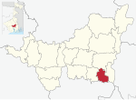
Bamandanga is a village in Chanditala II community development block of Srirampore subdivision in Hooghly district in the Indian state of West Bengal.
Excerpt from the Wikipedia article Bamandanga (License: CC BY-SA 3.0, Authors).Bamandanga
Geographical coordinates (GPS) Address Nearby Places Show on map
 Continue reading on Wikipedia
 Geographical coordinates (GPS)
| Latitude | Longitude |
|---|---|
| N 22.6878 ° | E 88.243 ° |
Address
712708
West Bengal, India
Open on Google Maps