Ala Wai Canal
1928 establishments in HawaiiCanals in HawaiiCanals opened in 1928Geography of HonoluluHistoric American Engineering Record in Hawaii ... and 1 more
Transportation in Honolulu

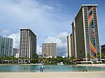
The Ala Wai Canal is an artificial waterway in Honolulu, Hawaii which serves as the northern boundary of the tourist district of Waikiki. It was created in 1928 to drain the rice paddies and swamps which would eventually become Waikiki. It also serves as a primary drainage corridor for the rivers and streams that run through central and east Honolulu. The canal runs from just northwest of Kapahulu Avenue along the length of Waikiki, then turns southwest to empty into the Pacific Ocean. Bridges cross the canal at McCully Street, Kalākaua Avenue, and Ala Moana Boulevard. Ala Wai Boulevard runs parallel to the west side of the canal in Waikiki.
Excerpt from the Wikipedia article Ala Wai Canal (License: CC BY-SA 3.0, Authors, Images).Ala Wai Canal
Ala Wai Foot Path, East Honolulu Kapahulu
Geographical coordinates (GPS) Address Nearby Places Show on map
Geographical coordinates (GPS)
| Latitude | Longitude |
|---|---|
| N 21.287222222222 ° | E -157.83111111111 ° |
Address
Ala Wai Foot Path
Ala Wai Foot Path
96815 East Honolulu, Kapahulu
Hawaii, United States
Open on Google Maps


