Theresienwiese
Parks and open spaces in Munich

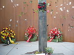
Theresienwiese is an open space in the Munich borough of Ludwigsvorstadt-Isarvorstadt. It serves as the official ground of the Munich Oktoberfest. A space of 420,000 square metres (4,500,000 sq ft), it is bordered in the west by the Ruhmeshalle and the Bavaria statue, symbolizing the State of Bavaria, and in the east by Esperantoplatz, a square named for the international language Esperanto. There, a memorial commemorates the victims of the 1980 Oktoberfest bombing. Bavariaring, an orbital road, provides access to visiting traffic. In the north the towers of the Paulskirche are visible.
Excerpt from the Wikipedia article Theresienwiese (License: CC BY-SA 3.0, Authors, Images).Theresienwiese
Hans-Fischer-Straße, Munich St. Paul (Ludwigsvorstadt-Isarvorstadt)
Geographical coordinates (GPS) Address Website External links Nearby Places Show on map
Geographical coordinates (GPS)
| Latitude | Longitude |
|---|---|
| N 48.133333333333 ° | E 11.55 ° |
Address
Theresienwiese (Oktoberfest)
Hans-Fischer-Straße
80336 Munich, St. Paul (Ludwigsvorstadt-Isarvorstadt)
Bavaria, Germany
Open on Google Maps


