St Albans, New Zealand

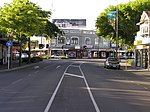
St Albans is a large, inner-northern suburb of Christchurch, New Zealand, located directly north of the Christchurch Central Business District. It is the second largest suburb in the city by population (behind Halswell), with a population of 13,137 at the 2018 Census. The suburb falls within the Christchurch Central electorate and is represented by Duncan Webb, who has been the member of parliament since the 2017 general election. St Albans is one of the most diverse residential neighbourhoods in Christchurch, with a wide range of densities, architectural styles and housing ages throughout the suburb. It has everything from run-down high-density council-owned flats, to modern luxurious high-density flats and apartments; old mid-density workers cottages through to large low-density estates of various ages.
Excerpt from the Wikipedia article St Albans, New Zealand (License: CC BY-SA 3.0, Authors, Images).St Albans, New Zealand
Rutland Street, Fendalton-Waimari-Harewood Community St Albans
Geographical coordinates (GPS) Address Nearby Places Show on map
 Continue reading on Wikipedia
 Geographical coordinates (GPS)
| Latitude | Longitude |
|---|---|
| N -43.508 ° | E 172.63 ° |
Address
Rutland Street 25
8146 Fendalton-Waimari-Harewood Community, St Albans
Canterbury, New Zealand
Open on Google Maps