Colerne

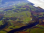
Colerne is a village and civil parish in north Wiltshire, England. The village is about 3.5 miles (6 km) west of the town of Corsham and 7 miles (11 km) northeast of the city of Bath. It has an elevated and exposed position, 545 feet (166 m) above sea level, and overlooks the Box valley to the south (where Brunel's Box Tunnel is). The parish includes the hamlets of Eastrip and Thickwood. It is bounded to the west by a stretch of the Fosse Way Roman road, which forms the county boundary with Gloucestershire, and to the east by the Bybrook River. Part of the northern boundary is the Doncombe Brook, a tributary of the Bybrook, and part of the southern boundary is the Lid Brook, another tributary.
Excerpt from the Wikipedia article Colerne (License: CC BY-SA 3.0, Authors, Images).Colerne
Tutton Hill,
Geographical coordinates (GPS) Address Nearby Places Show on map
Geographical coordinates (GPS)
| Latitude | Longitude |
|---|---|
| N 51.439 ° | E -2.262 ° |
Address
The Six Bells Inn
Tutton Hill
SN14 8DN
England, United Kingdom
Open on Google Maps


