place

Thwaites, Cumbria

Borough of CopelandCumbria geography stubsUse British English from September 2019Villages in Cumbria
St Anne's Church, Thwaites

Thwaites is a small village near Duddon Valley and on the edge of the Duddon Estuary in the Lake District National Park in the Borough of Copeland, Cumbria, England. The River Duddon flows through the valley, rising in the mountains between Eskdale and Langdale, before flowing into the Irish Sea near Broughton in Furness. In its lower reaches it is bounded by the Furness Fells and Harter Fell. Thwaites has an impressive sized church for the small population — the neighbouring villages of The Green, Broad Gate, Hallthwaites and Lady Hall all use St Anne's Church. Close by along the Duddon Valley are steep roads leading over the Hardknott Pass to Eskdale and east over the Wrynose Pass to the Langdale valleys. A less steep pass to Eskdale over Birker Fell leaves the Duddon Valley at Ulpha, with extensive views of the Scafell range. There is also the Corney Fell Road from Duddon Bridge or Broad Gate over to Waberthwaite and Broad Oak near Muncaster Castle.

Excerpt from the Wikipedia article Thwaites, Cumbria (License: CC BY-SA 3.0, Authors, Images).

Thwaites, Cumbria
Chapel Brow,

Geographical coordinates (GPS) Address Nearby Places
placeShow on map

Wikipedia: Thwaites, CumbriaContinue reading on Wikipedia

Geographical coordinates (GPS)

Latitude Longitude
N 54.257 ° E -3.259 °
placeShow on map

Address

Chapel Brow

Chapel Brow
LA18 5HP , Millom Without
England, United Kingdom
mapOpen on Google Maps

St Anne's Church, Thwaites
Share experience

Nearby Places

Swinside
Swinside

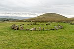
Swinside, which is also known as Sunkenkirk and Swineshead, is a stone circle lying beside Swinside Fell, part of Black Combe in southern Cumbria, North West England. One of around 1,300 recorded stone circles in the British Isles and Brittany, it was constructed as a part of a megalithic tradition that lasted from 3,300 to 900 BC, during what archaeologists categorise as the Late Neolithic and Early Bronze Ages.In this period, the Lake District – a mountainous area in which Swinside is located – saw particularly high levels of stone circle construction, with other notable examples including the Castlerigg stone circle and Long Meg and Her Daughters. The original purposes of these circles is still debated, although most archaeologists concur that they were built for ritual or ceremonial reasons. Constructed from local slate, the ring has a diameter of about 93 ft 8ins (26.8m), and currently contains 55 stones, although when originally constructed there probably would have been around 60. An entrance-exit was included on the monument's south-eastern side, which was defined by the inclusion of two outer portal stones. In the Early Modern period, local folklore about the stones held that they had once been used in the construction of a church, but that the Devil continually thwarted these plans, creating the stone circle in the process. Archaeological investigation into the monument began in the early 20th century, with an excavation taking place in 1901.