place

L Street Bridge

1980s architecture in the United StatesBridges over Rock Creek (Potomac River tributary)Georgetown (Washington, D.C.)Road bridges in Washington, D.C.
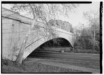
L Street Bridge deck 2015

The L Street Bridge is a bridge carrying the Rock Creek and Potomac Parkway over Rock Creek in Washington, D.C. It is the most downstream of three bridges where the Parkway switches from one side of the river to the other, the others being the bridge near P Street and the Shoreham Hill Bridge. Despite its name, the bridge does not carry or cross L Street, but it is adjacent to L Street's western terminus.The construction of the original bridge at this site was delayed by long-standing legal issues with the owners of the Chesapeake and Ohio Canal, which terminated at Rock Creek close to the position of the bridge. A lawsuit was initiated as early as 1912, but a resolution was not forthcoming. The situation changed in 1924 when a major flood damaged the canal to the point where it was uneconomical to repair it, strengthening the government's legal position. By 1931 these difficulties had been overcome and the bridge was scheduled to be completed by 1933.As the center portion of the parkway between K Street and P Street was the last to be completed, the L Street Bridge was initially unused while work continued. This middle portion was especially difficult to regrade and landscape because the valley had been used as an extensive dumping ground for debris and ashes.The original versions of both the L Street Bridge and Shoreham Hill Bridge were purposely built in a utilitarian style, using salvaged steel trusses from the Georgetown Aqueduct Bridge, in order to encourage the public to demand to replace them. The bridges were in fact replaced about ten years later. The current bridge was constructed from 1981 to 1983.

Excerpt from the Wikipedia article L Street Bridge (License: CC BY-SA 3.0, Authors, Images).

L Street Bridge
Rock Creek and Potomac Parkway, Washington

Geographical coordinates (GPS) Address Nearby Places
placeShow on map

Wikipedia: L Street BridgeContinue reading on Wikipedia

Geographical coordinates (GPS)

Latitude Longitude
N 38.903978 ° E -77.05659 °
placeShow on map

Address

Rock Creek and Potomac Parkway

Rock Creek and Potomac Parkway
20566 Washington
District of Columbia, United States
mapOpen on Google Maps

L Street Bridge deck 2015
Share experience

Nearby Places

K Street Bridge
K Street Bridge

The K Street Bridge is a complex of bridges over Rock Creek and the Rock Creek and Potomac Parkway in Washington, D.C. The lower level of the bridge carries the surface street K Street, while the upper level carries the Whitehurst Freeway (U.S. Route 29) which terminates and merges into K Street immediately east of the bridge. The central bridge is flanked by two flyover ramps that connect to the nearby terminus of Interstate 66.The first bridge on the site was a stone arch bridge constructed in 1792; it was only the second crossing of Rock Creek built, the first being at M Street. This bridge was found to be unstable and its center arch was demolished in 1795. In 1869, a wood bridge was constructed, and in 1907 it was replaced by a steel-plate girder bridge.The completion of the Rock Creek and Potomac Parkway in 1936 increased traffic on the K Street Bridge, necessitating its replacement. The lower level of the current bridge was constructed between 1939 and 1941, and the upper level, connecting to the Whitehurst Freeway, was constructed from 1947 to 1949. The designers of the current K Street Bridge also designed the Charles C. Glover Memorial Bridge farther up the river. The bridge is built of concrete, faced with gneiss. The flanking ramps were constructed in the early 1960s. They initially contained unused branches intended to connect to the unbuilt North Leg of the Inner Loop Expressway. These ramps were demolished in the mid-1990s.The bulk of the K Street Bridge, with its many ramps, was considered to be more of a visual barrier than the other bridges across Rock Creek. This was a result of transportation efficiency taking precedence over aesthetic concerns in this case, perhaps because at the time of its construction the surrounding neighborhoods were industrial or poor residential areas.