place

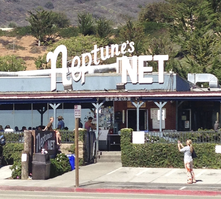
Neptune's Net

1958 establishments in CaliforniaBiker barsBuildings and structures in Malibu, CaliforniaRestaurants established in 1958Restaurants in Greater Los Angeles
Seafood restaurants in California
Neptune's Net 2
Neptune's Net 2

Neptune's Net is a seafood restaurant in Malibu, California. The landmark has been featured in countless television and film productions.

Excerpt from the Wikipedia article Neptune's Net (License: CC BY-SA 3.0, Authors, Images).

Neptune's Net
Pacific Coast Highway,

Geographical coordinates (GPS) Address Nearby Places
placeShow on map

Wikipedia: Neptune's NetContinue reading on Wikipedia

Geographical coordinates (GPS)

Latitude Longitude
N 34.053055555556 ° E -118.96194444444 °
placeShow on map

Address

Pacific Coast Highway

California, United States
mapOpen on Google Maps

Neptune's Net 2
Neptune's Net 2
Share experience

Nearby Places

Solromar, California

Solromar (portmanteau of Sol, Oro, and Mar, Spanish for "sun", "gold", and "sea") is a small unincorporated community in Ventura County, California, United States. Located at the north end of the Malibu coast, the community is just up the coast from Leo Carillo State Park. The community lies on a narrow coastal terrace along Pacific Coast Highway amidst some of the most diverse coastal terrain in Ventura County.: 91 County Line Beach Park lies in-between portions of the residential areas on the ocean side of the highway. A popular surf spot mentioned by the Beach Boys in their 1963 hit song "Surfin' USA", the beach is also popular for scuba diving and freediving with easy access, abundant kelp forest, and reefs. Solromar had a post office from 1944 to 1956. The post office selected the name from a list of twenty resident submissions. The Spanish words sol, oro, and mar were combined to suggest the description "golden sunset on the sea".This is the only residential community on the Malibu coast north of the Los Angeles County line. When Malibu incorporated as a city in Los Angeles County, this was the only community along the Malibu coast not to be included within the city limits. This portion of the south coast of Ventura County typically uses Malibu for the address as it is within a Malibu ZIP Code. Sewer service in the area is provided by individual septic tank systems.: 111 A California native garden and a monarch butterfly waystation were constructed as part of the MariSol subdivision. The U.S. Army Corps of Engineers has found a 0.9-foot per year (0.27 m) erosion rate for the shoreline, with major erosion occurring during the winter months.

Boney Peak
Boney Peak

Boney Mountain in Ventura County, California is one of the highest peaks in the Santa Monica Mountains. The prominent mountain visible from Newbury Park, California is 2,825 feet (861 m). It is also known as Boney Peak. The mountain contains four of the highest peaks in the coastal range of the Santa Monica Mountains: Boney Peak, Sandstone Peak, Exchange Peak, and Tri Peaks. The highest summit in the Santa Monica Mountains is Sandstone Peak (Mount Allen), situated less than a mile northeast of Boney Peak along the same ridge of volcanic rock. It is the top section of a mass of volcanic rock which solidified around 15 million years ago, and was later uplifted to its dominant position, overshadowing western Conejo Valley. The Chumash Native Americans have a long and deeply spiritual history of interaction at and near the mountain, and the peak is considered a sacred mountain to the Chumash people.It is located in the Circle X Ranch Park, within the Santa Monica Mountains National Recreation Area. The surrounding Boney Mountain State Wilderness Area lies within the eastern portion of Point Mugu State Park. Boney Mountain State Wilderness includes trail access to the rest of Point Mugu State Park, as well as Big Sycamore Canyon and Rancho Sierra Vista/Satwiwa Native American Indian Culture Center. Hiking trails from Satwiwa Native American Cultural Center in southernmost Newbury Park reach Boney Mountain and Peak, and feature views of the Pacific Ocean, Channel Islands, and Mount Baldy. Nearby trails lead to Danielson Monument and the Sycamore Canyon Waterfall. Boney Mountain was described by Chumash Indians to anthropologist John P. Harrington around year 1900: Early one morning in 9080 B.C., the ancestral grandfather from whom I took my name, headed west on one of his most adventurous hunting trips ever... As the group climbed Old Boney, they looked back to the north and could see the pleasant openings of the Conejo- and Hidden Valleys. There, there appeared to be good grazing ground for the mammoth herd and they proceeded thence. The story may be a lore related to the Paleo-Indians, the distant ancestors of the Chumash. An ancient Chumash village known as Satwiwa was located at the foothills of the mountain, which remains sacred to the Chumash people. Satwiwa is believed to be first inhabited 13,000 years ago, and was still a Chumash inhabitation site as of 2,000 years ago.In 2019, newspaper photos showed the peak was frosted with snow. Long time Newbury Park residents said it was the first time they had seen snow on the peak.