place

Neak Pean

12th-century Buddhist templesAngkorian sites in Siem Reap provinceBuddhist monastery stubsBuddhist temples in Siem Reap provinceCambodian building and structure stubs
Neakpeancentralpond2014

Neak Pean (or Neak Poan) (Khmer: ប្រាសាទនាគព័ន្ធ, "the entwined serpents") at Angkor, Cambodia is an artificial island with a Mahayana Buddhist temple on a circular island in Jayatataka Baray, which was associated with Preah Khan temple, built during the reign of King Jayavarman VII.: 389  It is the "Mebon" of the Preah Khan baray (the "Jayatataka" of the inscription).

Excerpt from the Wikipedia article Neak Pean (License: CC BY-SA 3.0, Authors, Images).

Neak Pean
Grand Circuit, Siem Reap

Geographical coordinates (GPS) Address Nearby Places
placeShow on map

Wikipedia: Neak PeanContinue reading on Wikipedia

Geographical coordinates (GPS)

Latitude Longitude
N 13.463055555556 ° E 103.89444444444 °
placeShow on map

Address

នាគព័ន្ធ

Grand Circuit
Siem Reap
Siem Reap, Cambodia
mapOpen on Google Maps

Neakpeancentralpond2014
Share experience

Nearby Places

Krol Ko
Krol Ko

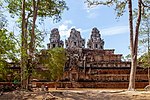
Krol Ko (Khmer: ប្រាសាទក្រោលគោ) at Angkor, Cambodia, is a Buddhist temple built at the end of the 12th century under the rule of Jayavarman VII, in his Bayon architectural style. It is north of Neak Pean. The name 'Krol Ko' is a modern term meaning 'The Park of the Oxen' and likely has no connection to its historical use. While speculative, it may have served as a chapel at a hospital site, as its layout is identical to the four hospital chapels found outside Angkor Thom (the 'Chapel of the Hospital' to the east, Ta Prohm Kel to the south, Tonle Sgnout to the north, and another site now in ruins to the west). Placement of a hospital close to Neak Pean would have made sense as Neak Pean was constructed as a representation of the waters of the mythical lake Anavatapta, which were thought to help the attainment of salvation amongst those deceased. Seven of the temple pediments at Krol Ko feature Lokeshvara, a boddhisattva who, in Khmer Buddhist belief, was entrusted with healing powers. Lokeshvara is commonly associated with hospitals.An interesting feature of Krol Ko is that while it was built as a Buddhist temple, it contains reliefs depicting a scene from the Hindu Puranas, which are medieval Hindu scriptures more contemporary than the classical Rigvedas. The left of the building shows Krishna raising the hill Govardhana to shelter shepherds and their flocks from a thunderstorm raised by Indra. This relatively contemporary Purana-Govardhana story displays Indra's submission to Krishna, despite Indra being viewed as the supreme deity in the Rigvedas. In Buddhism, Indra remained as the superior deity and was even venerated as a protector of the Buddhist faith whilst worship amongst the Hindu population shifted towards Shiva, Durga, Vishnu and Krishna since the medieval period. It is therefore striking that the Govardhana tale, a tale that tells of Indra's inferiority to Krishna, is depicted in an otherwise Buddhist temple. This indicates a lack of rivalry between the Buddhist and Hindu populations residing within Angkor, contrary to India, where Buddhism was deemed as heretical amongst many Hindus due to its renunciation of the caste system. The caste system was never entirely adopted by the Khmer civilization and other South-East Asian civilizations. The approximate location of the site is 13.468189' N, 103.895401' E (WGS 84 map datum).

East Mebon
East Mebon

The East Mebon (Khmer: ប្រាសាទមេបុណ្យខាងកើត) is a 10th Century temple at Angkor, Cambodia. Built during the reign of King Rajendravarman, it stands on what was an artificial island at the center of the now dry East Baray reservoir.: 73–75 : 116  The East Mebon was dedicated to the Hindu god Shiva and honors the parents of the king. Its location reflects Khmer architects’ concern with orientation and cardinal directions. The temple was built on a north–south axis with Rajendravarman's state temple, Pre Rup, located about 1,200 meters to the south just outside the baray. The East Mebon also lies on an east–west axis with the palace temple Phimeanakas, another creation of Rajendravarman's reign, located about 6,800 meters due west. Built in the general style of Pre Rup, the East Mebon was dedicated in 953 AD. It has two enclosing walls and three tiers. It includes the full array of durable Khmer construction materials: sandstone, brick, laterite and stucco. At the top is a central tower on a square platform, surrounded by four smaller towers at the platform's corners. The towers are of brick; holes that formerly anchored stucco are visible. The sculpture at the East Mebon is varied and exceptional, including two-meter-high free-standing stone elephants at corners of the first and second tiers. Religious scenes include the god Indra atop his three-headed elephant Airavata, and Shiva on his mount, the sacred bull Nandi. Carving on lintels is particularly elegant. Visitors looking out from the upper level today are left to imagine the vast expanses of water that formerly surrounded the temple. Four landing stages at the base give reminder that the temple was once reached by boat.

East Baray

The East Baray (Khmer: បារាយណ៍ខាងកើត), or Yashodharatataka, is a now-dry baray, or artificial body of water, at Angkor, Cambodia, oriented east–west and located just east of the walled city Angkor Thom. It was built around the year 900 AD during the reign of King Yasovarman.: 113, 116  Fed by the Siem Reap River flowing down from the Kulen Hills, it is the second-largest baray in the Angkor region (after the West Baray) and one of the largest handcut water reservoirs on Earth, measuring roughly 7.5 kilometers by 1830 m and holding over 55 million cubic meters of water. Stones bearing inscriptions that mark the construction of the baray have been found at all four of its corners.: 65  The labour and organization necessary for its construction were staggering: Its dikes contain roughly 8 million cubic meters of fill.: 68  Scholars are divided on the purpose of this and other barays. By some theories, they held water for irrigation, but no inscription has been found mentioning such a function. Other theories say that barays served primarily a symbolic purpose in Khmer religious life, representing the seas of creation that surround Mount Meru, home of the Hindu gods.: 60  The East Baray today contains no water; farmers till crops on its bed. But its outlines remain clearly visible in satellite photographs. In the middle of the baray is the East Mebon temple, located on elevated ground that was an island in the days when the baray contained water.