Eagle Peak Mendocino County AVA
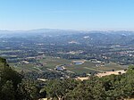
Eagle Peak Mendocino County is an American Viticultural Area located in Mendocino County, California and established on November 10, 2014, by the U.S. Department of Treasury's Alcohol and Tobacco Tax and Trade Bureau (TTB). It lies within the North Coast AVA and takes its name from the nearby Eagle Peak summit covering the mountainous area situated in the California Coastal Range just west of the Redwood Valley AVA and east of the V-shaped Mendocino AVA. It was first proposed in June 2013, designating roughly 26,260 acres (10,627 ha) and straddles U.S. Highway 101 between the towns of Ukiah and Willits. The new boundaries reduced about 1,500 and 1,900 acres (607 and 769 ha) from each bordering AVA to eliminate overlap with Eagle Peak Mendocino County.
Excerpt from the Wikipedia article Eagle Peak Mendocino County AVA (License: CC BY-SA 3.0, Authors).Eagle Peak Mendocino County AVA
Reeves Canyon Road,
Geographical coordinates (GPS) Address Nearby Places Show on map
Geographical coordinates (GPS)
| Latitude | Longitude |
|---|---|
| N 39.2758 ° | E -123.2567 ° |
Address
Reeves Canyon Road 607
95470
California, United States
Open on Google Maps


