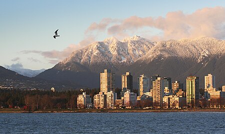
West End, Vancouver

The West End is a neighbourhood in Vancouver, British Columbia, Canada, located between the Coal Harbour neighbourhood and the financial and central business districts of Downtown Vancouver to the east, Stanley Park to the northwest, the English Bay to the west, and Kitsilano to the southwest across the False Creek opening. The West End is not to be confused with the West Side (which denotes the western half of the non-downtown part of Vancouver city to the south) or West Vancouver ("West Van"), a separate municipality (conversely, and to the confusion of some, "East Van", "the East End", and "the East Side" all denote East Vancouver). The definition of the "official neighbourhood" of the West End, according to the city, is the area west of Burrard Street, east of Lost Lagoon, and south of West Georgia Street. Historically the term originated and remains used by Vancouverites to refer to everything from Burrard Street to Stanley Park, including the Stanley Park Neighbourhood west of Denman Street and the Coal Harbour Neighbourhood. Coal Harbour Neighbourhood is officially designated as west of Burrard and to the north of West Georgia, although the newly built areas between West Pender Street and the waterfront are expressly "Coal Harbour" and not considered part of the West End.
Excerpt from the Wikipedia article West End, Vancouver (License: CC BY-SA 3.0, Authors, Images).West End, Vancouver
Comox Street, Vancouver West End
Geographical coordinates (GPS) Address Nearby Places Show on map
Geographical coordinates (GPS)
| Latitude | Longitude |
|---|---|
| N 49.285 ° | E -123.134 ° |
Address
Comox Street
Comox Street
V6E Vancouver, West End
British Columbia, Canada
Open on Google Maps


