place

Southport Town Hall

Buildings and structures in SouthportCity and town halls in MerseysideGovernment buildings completed in 1853Grade II listed buildings in MerseysideUse British English from April 2022
Southport Town Hall geograph.org.uk 1369488

Southport Town Hall is on the east side of Lord Street, Southport, Sefton, Merseyside, England. It was built in 1852–53 in Palladian style, and extended to the rear on three occasions later in the century. The town hall has a symmetrical stuccoed façade with a central staircase leading up to a porch flanked by columns. At the top of the building is a pediment with a carved tympanum. The town hall is recorded in the National Heritage List for England as a designated Grade II listed building.

Excerpt from the Wikipedia article Southport Town Hall (License: CC BY-SA 3.0, Authors, Images).

Southport Town Hall
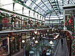
Cambridge Arcade,

Geographical coordinates (GPS) Address External links Nearby Places
placeShow on map

Wikipedia: Southport Town HallContinue reading on Wikipedia

Geographical coordinates (GPS)

Latitude Longitude
N 53.6475 ° E -3.0056 °
placeShow on map

Address

Southport Town Hall

Cambridge Arcade
PR8 1AS
England, United Kingdom
mapOpen on Google Maps

linkWikiData (Q18085745)
linkOpenStreetMap (42083657)

Southport Town Hall geograph.org.uk 1369488
Share experience

Nearby Places

Southport
Southport

Southport is a seaside town in the Metropolitan Borough of Sefton in Merseyside, England. At the 2021 census, it had a population of 94,421, making it the eleventh most populous settlement in North West England.Southport lies on the Irish Sea coast and is fringed to the north by the Ribble estuary. The town is 17 miles (27 km) north of Liverpool and 15 miles (24 km) southwest of Preston. Within the boundaries of the historic county of Lancashire, the town was founded in 1792 when William Sutton, an innkeeper from Churchtown, built a bathing house at what is now the south end of Lord Street. At that time, the area, known as South Hawes, was sparsely populated and dominated by sand dunes. At the turn of the 19th century, the area became popular with tourists due to the easy access from the nearby Leeds and Liverpool Canal. The rapid growth of Southport largely coincided with the Industrial Revolution and the Victorian era. Town attractions include Southport Pier, the second longest seaside pleasure pier in the British Isles, and Lord Street, an elegant tree-lined shopping street. Extensive sand dunes stretch for several miles from Woodvale to Birkdale, the south of the town. The Ainsdale sand dunes have been designated as a national nature reserve and a Ramsar site. Local fauna include the natterjack toad and the sand lizard. The town contains examples of Victorian architecture and town planning, on Lord Street and elsewhere. A particular feature of the town is the extensive tree planting. This was one of the conditions required by the Hesketh family when they made land available for development in the 19th century. Hesketh Park at the northern end of the town is named after them, having been built on land donated by Rev. Charles Hesketh.Southport today is still one of the most popular seaside resorts in the UK. It hosts various events, including an annual air show on and over the beach, the largest independent flower show in the UK (in Victoria Park) and the British Musical Fireworks Championship. The town is at the centre of England's Golf Coast and has hosted the Open Championship at the Royal Birkdale Golf Club.